Tilicho Lake Trek via Annapurna Circuit & Thorong La - 11 Days
The 11-Day Annapurna Circuit with Tilicho Lake package is a moderate to challenging trek reaching 5,...
OVERVIEW & HIGHLIGHTS
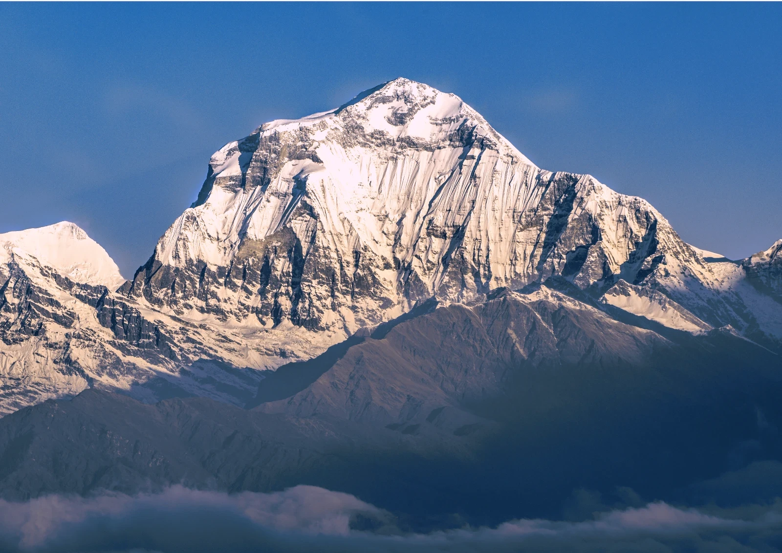
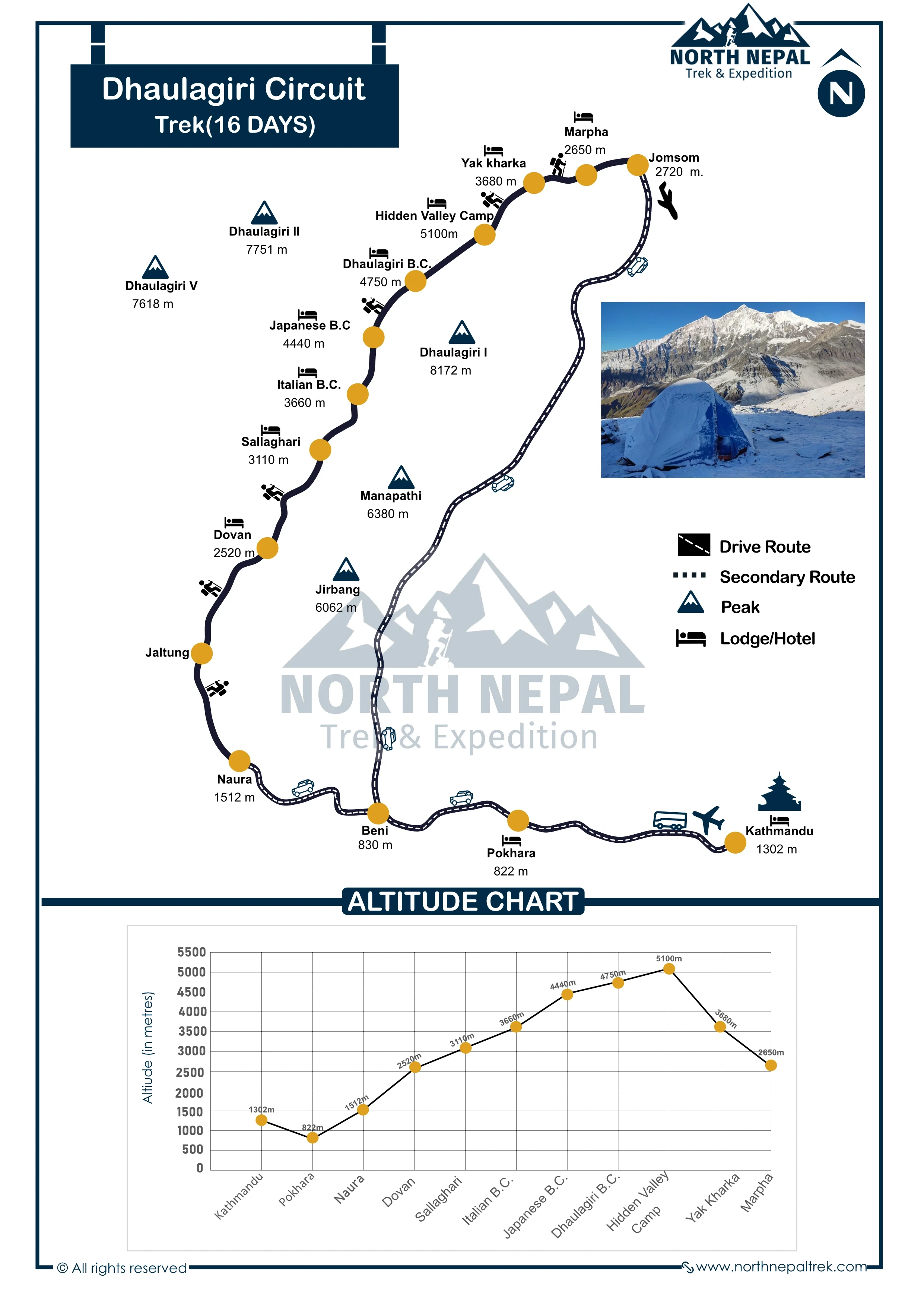
The 16-Day Dhaulagiri Circuit package starts from Kathmandu via Beni after UNESCO World Heritage Exploration in Kathmandu. Then rounding the Dhaulagiri I (8,167m), the 7th highest mountain in the world, remote high-altitude terrain through Rhododendron forests, glaciers, rocky moraines, and the high-altitude plateau of Hidden Valley (5,100m).
The route crosses two major expedition-grade passes: French Pass (5,360m / 17,585ft), the highest point of the trek, and Dhampus Pass (5,240m), with mandatory camping at Italian Base Camp (3,660m), Japanese Base Camp (4,200m), Dhaulagiri Base Camp (4,750m), and Hidden Valley. The trek passes through the Gurung & Magar settlement of Maygdi to the Thakali community of the Lower Mustang region. An ACAP permit (NPR 3,000) & Dhaulagiri Restricted Area Permit (USD 20 per week) are required. Recommended for experienced trekkers seeking challenges in life only.
Kumar Gurung, Trekking Guide
Dhaulagiri Circuit Trek route and logistics are drawn from 12+ years guiding North Nepal high-altitude expeditions. Mohan founded North Nepal Trek in 2015; since then, Kumar Gurung has guided multiple Dhaulagiri Circuit expeditions.
We will explore the heart of culturally rich Kathmandu Valley. We visit Pashupatinath, where life and death coexist on the sacred Bagmati River. We continue to Boudhanath, walking clockwise with monks and pilgrims beneath one of the largest stupas in the world. The day ends at Patan Durbar Square, a masterpiece of Newari architecture. This day sets the cultural and spiritual context for the journey ahead.
We leave the capital and travel west toward Pokhara, either by a scenic 6- to 7-hour drive following the Trishuli & Marshyangdi River, or by a quick 25-minute flight with Himalayan views. Pokhara feels lighter and calmer after leaving bustling Kathmandu. The lakeside atmosphere and the first clear views of the Machhapuchre (Fish Tail), Annapurna, and other peaks amaze you.
On the fourth day, we drive from Pokhara into the Myagdi region, reaching the road head at Naura. From here, we begin walking. The trail immediately pulls us away from comfort and into rural Nepal, small villages, suspension bridges, and forested paths. We trek to Jaltung, where the expedition truly begins. This is the last taste of settled life before entering the remote core of the Dhaulagiri Circuit.
On the fifth day, we trek a longer trek route of about 6-7 hours from Jaltung to Doban. The trail leads us through thick forests, and at times we walk alongside the Myagdi Khola river.
Photo: Clouds hovering over the hills of Dovan during Dhaulagiri Circuit Trek.
The path includes some ascents and descents, providing a quick warmup and challenges for trekkers. The peaceful environment and lush greenery make the hike through the forest more enjoyable. By the time we reach Doban, a remote area perfect for camping, we are ready to rest. Overnight stay at the camp.
On the sixth day of the trek, we enter a dense forest after crossing Kunaban Khola. The trail leads us through dense forests filled with rhododendrons, bamboo, and pine trees, creating a serene and peaceful atmosphere.
Photo: Sallaghari; the last tree line region of the Dhaulagiri Circuit Trek.
The path includes steady ascents and occasional river crossings, adding both adventure and scenic beauty to the journey. As we walk through the lush greenery, we might spot wildlife such as langur monkeys or colorful birds. The gradual thinning of vegetation as we gain altitude reminds us of our approach to Sallaghari.
By the time we reach Sallaghari, a beautiful forest clearing at 2820 m above Dovan, we are greeted and surrounded by towering trees. Overnight stay at the camp.
Today, we head towards the Italian Base Camp at an altitude of 3,660 meters. The trek takes about 5 to 6 hours and involves a steep ascent through forests and rocky terrain.
Photo: Italian Base Camp, where the difficult section starts forthe Dhaulagiri Trek
As we climb higher, the trees thin out, and we get closer views of the Dhaulagiri peaks. After reaching the Italian Base Camp, we are rewarded with stunning mountain scenery all around. It's an ideal spot to relax and soak in the majestic views. This day is a transition from lush sub-tropical forest to the arid landscape of the Dhaulagiri region. Overnight stay at the camp.
This day is dedicated to acclimatization at the Italian Base Camp. We spend the day resting and allowing our bodies to adjust to the higher altitude, which is important for our health and safety.
We can take short hikes around the camp to explore the area and enjoy panoramic views of the Dhaulagiri range. This rest day prepares us for the higher elevations we'll encounter ahead. Overnight stay at the camp.
On the ninth day of the Dhaulagiri Circuit Trek, we trek from the Italian Base Camp to the Japanese Base Camp. The trail becomes significantly more challenging due to landslides, debris, and rockfalls, which alter the path every year.
Photo: Trail through Japanese Base Camp along the moraine and glacier stream on the Dhaulagiri trek.
Instead of following a set trail, a team of experts goes ahead to make a new path for the group to safely reach the Japanese Base Camp. This is why having experienced guides is crucial—they ensure the safety of trekkers in these unpredictable and dangerous conditions.
The trek takes about 5 to 6 hours, and during the day, with too much snow and icy conditions, we will use ladders and ice axes to cross the difficult sections.
As we ascend, the landscape becomes rugged and barren, making this one of the most physically demanding days of the trek. Upon reaching the Japanese Base Camp, we set up camp in a high-altitude environment surrounded by dramatic mountain terrain. Overnight stay at the camp.
We make our way to the Dhaulagiri Base Camp at an altitude of 4,750 meters. The trek lasts about 5 to 7 hours over rocky and glacier-covered terrain.

The views are spectacular, with towering peaks and glaciers surrounding us. After reaching the base of Dhaulagiri I, a thrilling experience, we set up our camp feeling a great sense of accomplishment. Overnight stay at the camp.
On the eleventh day of the Dhaulagiri Circuit Trek, we face one of the most challenging and rewarding sections by crossing the French Pass at an altitude of 5,360 meters. We start early in the morning, ascending steadily to cope with the high altitude and thinning air.
Photo: Hidden Valley of Dhaulagiri Circuit Trek
The French Pass is one of the highest points of the trek, and its ascent can be tough due to the steep incline, exposed terrain, and unpredictable weather conditions. However, the effort is worth it, as the views from the top are breathtaking, offering a panoramic vista of the surrounding peaks, including Dhaulagiri, Tukuche Peak, and the Hidden Valley in the distance.
The pass itself is often windy, and snow can make the ascent more difficult, which is why it’s important to pace yourself and stay hydrated. After enjoying the incredible views at the top, we begin a descent into the windy Hidden Valley, a vast and remote area surrounded by towering, snow-capped peaks.
The Hidden Valley feels like another world, with its stark, barren landscape and complete isolation from civilization. We set up camp in this serene, high-altitude valley, where the silence and beauty create a sense of peace and solitude. Overnight stay at the camp.
On this day, we face another challenging section as we cross the Dhampus Pass at 5,240 meters. The trail is narrow and follows a ridge, with steep drops on either side, requiring careful footing.
Photo: Yak Kharka of Dhaulagiri Trek.
The area is known for strong winds, making the trek more demanding. We walk steadily along the narrow path, surrounded by the rugged beauty of the high mountains.
After several hours, we begin our descent towards Yak Kharka. The day's trek takes about 6 to 8 hours, and we feel a great sense of achievement upon reaching Yak Kharka. We set up our camp here and will take a rest after this tough but rewarding day. Overnight stay at the camp.
Today, our trek begins with a descent from Yak Kharka to the charming village of Marpha, famous for its apple orchards and unique Thakali architecture. The trail takes us through stunning alpine landscapes as we lose altitude, offering a refreshing change in scenery.
Photo: Marpha, the ending point of the Dhaulagiri trek
Upon reaching Marpha, we take some time to explore its narrow stone-paved streets and sample its renowned apple products, such as cider and pies. The village's peaceful atmosphere and distinct cultural vibe make it a memorable stop.
After completing the trek, a 25-minute flight from Jomsom to Pokhara offers a quick and scenic route back. The flight provides stunning aerial views of the Himalayas, valleys, and rivers, making it a memorable end to the trekking adventure.

Drive from Jomsom to Pokhara
For those who prefer a more gradual return, there's an option to drive from Jomsom to Pokhara. The journey by road takes around 7-8 hours, passing through beautiful landscapes, charming villages, and along the banks of the Kali Gandaki River. While it is longer, this option allows for an extended exploration of the region, offering a different perspective of the scenery compared to the flight.
We will retrace the same route. You will either take a flight for a quick reach or take a highway for a road journey.

Your trek formally ends with a departure from Nepal. Our representative will drop you off at Tribhuwan International Airport (TIA). Support you with the necessary procedure before departure.
Itineraries are structured with careful elevation profiles and a dedicated acclimatization day at Italian Base Camp (3,660 m) before the group continues toward Japanese Base Camp (4,200 m), Dhaulagiri Base Camp (4,750 m), and the high-altitude plateau of Hidden Valley (5,100 m). Guides conduct rigorous daily health assessments for early symptoms of Acute Mountain Sickness (AMS), and if severe symptoms appear, standard protocol mandates immediate descent to lower elevations.
In cases of severe injury, acute altitude illness, or extreme weather on the remote, camping-only sections of the Dhaulagiri Circuit, emergency helicopter evacuation is coordinated directly through local rescue services, adhering strictly to regional aviation regulations set by CAAN. Evacuations are initiated promptly upon assessment by your guide in communication with our Kathmandu and Pokhara offices, though rescue timing can be weather-dependent given the trek’s remoteness.
All trekkers must hold comprehensive travel insurance covering emergency medical treatment, high-altitude trekking up to 5,360 m (French Pass), and emergency helicopter rescue/evacuation. Policies should also protect against trip cancellations, delays, and gear loss. Insurance details must be submitted prior to departure to streamline emergency logistics if required.
Secure the Dhaulagiri Circuit Trek for 2026/2027 before the seat gets fully booked.
The Dhaulagiri Circuit Trek typically takes 16 days, covering approximately 102 km around the Dhaulagiri Massif. The itinerary includes an acclimatization day at Italian Base Camp (3,660 m). The trek can also be extended to around 20 days for a slower pace or additional acclimatization.
The Dhaulagiri Circuit is rated Strenuous to Extremely Challenging. It involves long days at high altitude, technical mountain terrain, two high passes above 5,000 m, glacier and moraine sections, remote camping and rapidly changing weather. Previous high-altitude trekking experience and excellent physical fitness are essential.
No. This trek isn't suitable for beginners. The combination of altitude, technical terrain, remote campsites, limited rescue infrastructure and prolonged camping requires experience at elevations of at least 4,000 m.
Daily distances generally range from 8 to 18 km, with around 5 to 8 hours of walking. Distance alone doesn't reflect the difficulty because steep terrain and altitude make some shorter stages particularly demanding.
No. Camping is an integral part of the Dhaulagiri Circuit. Once you leave the lower settlements, there are no alternative teahouses or lodges to replace the expedition-style camps.
The Dhaulagiri Circuit passes through remote mountain communities with far less tourism infrastructure than routes such as the Annapurna Circuit or Everest Base Camp Trek. The journey combines wilderness trekking with encounters in isolated settlements before entering the high-altitude Dhaulagiri landscape.
The exact equipment depends on current trail and snow conditions, but crampons, sturdy high-ankle trekking boots and appropriate cold-weather equipment are essential for the high-pass and glacial sections. Your trekking operator should confirm the final technical gear list before departure.
A sleeping bag rated to approximately -25°C is recommended for the high camps. Nights at Italian Base Camp and above can be severely cold, so an insulated sleeping pad is also important.
Some trekking equipment can be rented in Nepal, but specialized equipment for a demanding expedition should be arranged and checked well before departure. Confirm with your trekking company which group equipment is supplied and which personal equipment you need to bring.
Personal expenses, international flights, Nepal visa costs, personal trekking equipment and other services not listed in the package inclusions should be budgeted separately. Because the Dhaulagiri Circuit requires extensive camping logistics and support staff, its cost is considerably higher than standard teahouse treks.
A solo attempt isn't recommended. The route is extremely remote, technically demanding and difficult to navigate, with limited emergency infrastructure. A private guided expedition with an experienced trekking team is the safer approach.
Yes. The route enters a restricted area and requires organized trekking with registered guides. An experienced guide is particularly important because of the difficult navigation, glacier terrain, high passes and limited communication.
Yes. The itinerary can be adjusted around your available time, acclimatization needs and trekking experience. Longer versions of the route can allow additional rest or acclimatization days.
Spring and autumn are the preferred seasons. Spring offers warmer conditions, rhododendron blooms at lower elevations and generally good mountain visibility. Autumn normally provides the clearest skies and most stable trekking conditions.
It's not recommended. June to August brings heavy rainfall to the lower sections, increasing the risk of slippery trails, landslides and unstable mountain conditions.
Conditions become significantly colder as the route climbs. At high camps around 4,500 to 5,360 m, temperatures can fall well below freezing at night, with strong winds and sudden snowfall possible. Weather at the passes can change rapidly, even when conditions are clear earlier in the day.
Altitude sickness is a major safety concern because the trek spends several consecutive days above 4,000 m, with the highest pass reaching 5,360 m. Symptoms can include headache, nausea, insomnia, dizziness and loss of appetite.
The itinerary includes an acclimatization day at Italian Base Camp. Trekkers should ascend gradually, stay hydrated, avoid alcohol at altitude and report symptoms to their guide immediately.
Begin preparing several months before departure. Training should combine cardiovascular exercise, strength training and long-distance hiking. Regular uphill hikes with a loaded daypack are particularly useful. Previous experience on a trek above 4,000 m is strongly recommended.
Emergency response is limited because much of the route is remote and there is no conventional rescue infrastructure. Helicopter evacuation may be possible when weather, altitude and landing conditions permit, but evacuation can be delayed by storms, cloud cover and difficult landing locations.
A comprehensive insurance policy covering high-altitude trekking and emergency evacuation is essential.
Yes. Comprehensive travel insurance is essential for the Dhaulagiri Circuit. The policy should specifically cover high-altitude trekking, medical treatment, emergency helicopter evacuation, trip interruption and personal accident risks. Standard travel insurance policies may exclude trekking at these elevations, so check the policy wording carefully.
The Dhaulagiri Circuit needs two permits:
The Dhaulagiri Restricted Area Permit costs USD 20 per week with a two-week minimum, while the ACAP costs NPR 3,000 (about USD 25).
The restricted-area designation helps regulate tourism in a fragile and remote mountain environment. It also supports conservation, protects local communities and cultural heritage, and provides a framework for managing trekkers in an area where rescue and infrastructure are limited.
No separate mountaineering permit is required for the trek itself. A mountaineering permit is required if you intend to climb Dhaulagiri I, which is a separate mountaineering expedition.
Transportation is used to reach the lower trailhead and to connect with the route before and after the trekking section. Because road conditions in the Dhaulagiri region can change, the exact vehicle arrangements should be confirmed in the final itinerary.
The Dhaulagiri Circuit is primarily a camping trek. Basic teahouse accommodation may be available during the early section, but from Italian Base Camp onward there are no regular lodges or teahouses.
The trekking team therefore carries tents, food, cooking equipment and other camp supplies, supported by porters or pack animals where required.
Camping is expedition-style rather than luxury camping. The setup normally includes two-person sleeping tents, dining tents, kitchen facilities and basic toilet tents.
Camps are often in exposed mountain environments, so trekkers should expect cold temperatures, wind and limited facilities.
A trekking cook prepares meals from supplies carried by the support team.
Typical meals include:
Vegetarian meals are standard, and special dietary requirements should be communicated before departure. Carrying personal snacks such as chocolate, nuts and energy bars is also recommended.
Water is collected from available natural sources and treated for drinking. In remote camps, particularly Hidden Valley, sufficient water must be carried because reliable sources may not be available nearby. Water purification tablets or another suitable treatment method should be carried as a backup.
Mobile coverage is very limited to nonexistent across much of the remote circuit. Trekkers should expect several days without normal mobile or internet connectivity.
Because conventional mobile networks aren't reliable, the trekking team should have satellite communication for emergencies and operational contact. This is especially important when crossing remote high-altitude terrain.
The route provides views of the Dhaulagiri Massif, including:
The combination of the massive Dhaulagiri range, glaciers, moraines, high passes and remote valleys is one of the defining features of the trek.
The route moves from lower mountain forests into increasingly rugged terrain, eventually reaching glacial valleys, moraines, high mountain passes and exposed alpine camps. The contrast between the lower valleys and the remote high-altitude wilderness is what makes the Dhaulagiri Circuit fundamentally different from Nepal's established teahouse trekking routes.