Kori Himal Trek - 6 Days
The Kori Himal Trek package 6-day short trek from Pokhara with mountain views and cultural expo...
OVERVIEW & HIGHLIGHTS
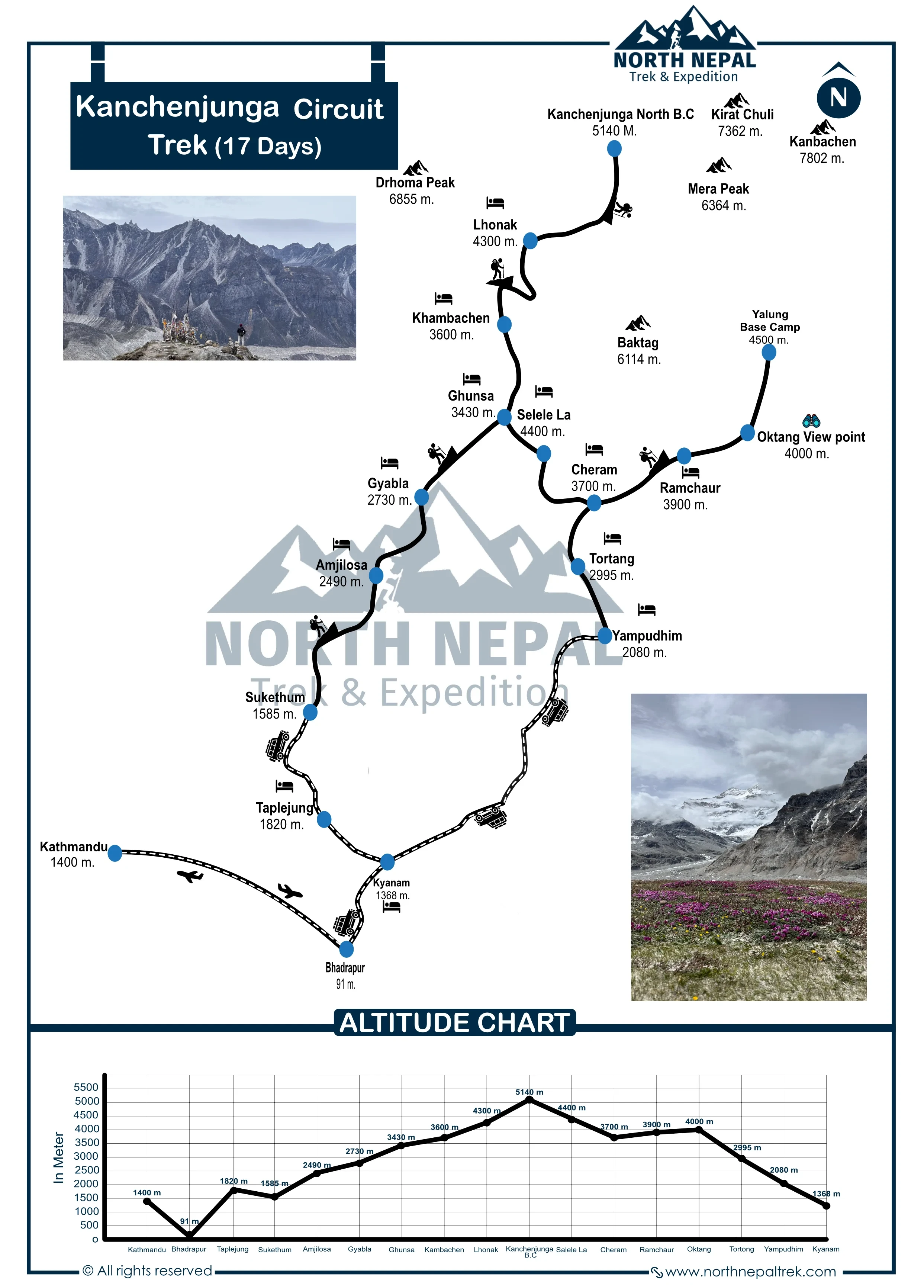
The 17-Day Kanchenjunga Circuit package via Olangchung Gola, combines classic Kanchenjunga North Base Camp (5,143m) & South Base Camp with the rarely walked ancient Tibet trade route, covering ~202km through the Kanchenjunga Conservation Area in Eastern Nepal. This route detours through Olangchung Gola (3,191m), home to the 16th-century Diki Chhyoling monastery and Tibetan Sherpa community, before crossing Nango La Pass (4,910m) to rejoin the main trail at Ghunsa.
The circuit crosses three high passes: Nango La (4,910m), Mirgin La (4,665m) & Sele La (4,290m), passing the Yalung Glacier and offering views of Kanchenjunga (8,586m) — the world's 3rd highest mountain, Kumbhakarna / Jannu (7,711m), and Makalu (8,485m), the world's 5th highest peak. Two permits are required: Kanchenjunga Conservation Area Permit (USD 20 for one time use) & Restricted Area Permit (USD 20 per person for a week). As of March 22, 2026, you don't need a another trekker to walk in the Kanchenjunga region of East Nepal. Licensed guides are mandatory. Strenuous grade; recommended for experienced trekkers.
Major Mountain Pass in the 17 Day Trek:
| Kanchenjunga Circuit Pass | Elevation |
|
Nango La Pass |
4,910 m | 16,108 ft |
|
Sele La Pass |
4,290m | 14,075 ft |
|
Mirgehla Pass |
4,665 m | 15,305 ft |
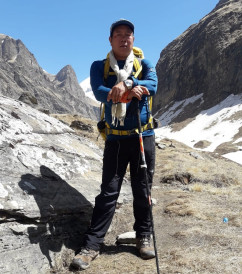
Kumar Gurung, Trekking Guide
Kanchenjunga Circuit Trek route and pacing are drawn from years guiding the remote Kanchenjunga region. Mohan founded North Nepal Trek in 2015; since then, Kumar Gurung has led multiple treks through Olangchung Gola and the Kanchenjunga Conservation Area.
After a night at the local lodges in Taplejung, we will get up early and start our drive. Today, our destination will be Olangchung Gola. During our trip, we will cross through several jungles and also witness the settlements of Rai, Limbus, and Sherpas. We will also travel through the banks of the Tamber Khola, the largest river in Taplejung.

Photo: Olangchung Gola
The trek continues through fragrant rhododendron-covered slopes (in spring, crimson blooms dominate). A sense of mystery arises as mani prayer wheels creak in the mountain wind as you approach Olangchung Gola, ending at 3,191m, where traditional stone-slate roofs frame the snow-capped peaks of Kumbhakarna.
The trail from Olangchung Gola to Lyangyoug Kharka is more accessible than the other trail. There are steps at some points, and we will cross several suspension bridges. During our trek to Kanchenjungha Base Camp, we will encounter several forests and small lakes.
Photo: Lyangyoug Kharka
As a result, you will get to explore various flora and fauna, as well as the Rocky Mountains and waterfalls. We also want to remind you that no hotels or villages are available during our trek, so make sure you carry enough packed food and drinks.
We will finally reach our destination, which is about 17 kilometers away from Olangchung Gola, after trekking for 9 hours. We will spend the night and continue our journey the following day.
Today is the logistical crux. We leave the trade route and head west towards Ghunsa. The ascent to Nango La involves navigating loose scree and potential snow patches (crampons recommended in early spring). From the summit, the view opens up to the Kumbhakarna (Jannu) Massif. The descent into the Yangma Khola valley is sharp and requires careful footing before we reach the Sherpa capital of Ghunsa.
Photo: On the way to Nangola Pass
The trail to Nango La Pas is very steep and rocky as well. One must be careful about their steps, as the path can be slippery and risky. As we reach Nango La Pass, you will witness the breathtaking views of the hills and mountains. Overall, this trail is tricky, but it is worth the view.
This trail includes loose rock and a technical route as we pass the Rocky Nango La Pass. Then, we will descend to Ghunsa, a small village where Sherpas reside. As we trek for 11-12 hours, covering a distance of 22 kilometers from Langyoug Kharka, we will finally reach Ghunsa, where we will spend our night and immerse ourselves in their culture.
The trail from Ghunsa to Khanbachen is one of the most beautiful parts of the Kanchenjunga Circuit Trek. To reach there, we will cross several small waterfalls and suspension bridges and witness the mesmerizing view of the mountains.

Photo: Hazare Cave
Another essential feature of this trail is Kumbakarna Mountain. This mountain is also popularly known as Janu Mountain by the Tibetan people. As we continue our trail, we will encounter a ward called Hajare Wada. People believe that many years ago, they would sign an agreement at this place to maintain peace between the Kirants from Nepal and the Mongolians from Darjeeling. But Kirants cheated the Mongolians and poisoned the food, causing the deaths of thousands of people. So, they named this place Hajare Wada to remember the deceased people.
As we continue our trail from the Hajare Wada, we will eventually reach Khambachen after covering a distance of 11 kilometers for about 5 hours. We will rest, gather our energy at the local inns, and continue our journey the following day.
Today, we will acclimatize ourselves to prevent acute altitude sickness. One can rest or walk around the places in Kambachen to stretch their legs and train for the upcoming challenges. After enjoying the morning scenery with tea, we will head towards Nupchu Lake and Nupchu Viewpoint to explore and enjoy their beauty.

The path towards these destinations is quite steep and slippery. One must be cautious and aware of the trails. As we reach Nupchu Lake, you will be amazed at how heavenly the earth is. The view from the Nupchu Viewpoint will also mesmerize you with its beauty. After spending quality time here, we will return to our inns and prepare for our upcoming trail.
Today, we will go to Lonak, a small but beautiful village in the region of Kanchenjunga, and gain around 500 meters of elevation. The trail to Lonak is moderate but risky at some points, as these places are rocky and can have landslides. There are also numerous thorns, like flowers, so one must be aware of them as they might cause extreme pain in the body.

Photo: Lonak
You will witness glaciers, waterfalls, lakes, and, most importantly, the view of the majestic mountains throughout your trek. After covering a distance of 11 kilometers and trekking for 5 hours, we will finally reach Lonak, which lies at an elevation of 4790 meters.
This day will be the most challenging and unique part of the Kanchenjunga Circuit Trek. The trail to the Kanchenjunga North Base Camp is narrow and slippery, making it difficult for us to trek. The paths are also swayed by small waterfalls and glaciers, making them narrower and more dangerous.
Photo: Herd of Blue Sheep on the Way to KBC
On this day, we will have to go above an elevation of 5000 meters; as a result, one may suffer from high-altitude sickness. People used this route for expeditions, but it has been changed to South Base Camp since it includes many rocky and slippery areas, so this trail may be pretty tough and challenging for us.
However, one must be well-prepared and aware of the consequences and preventive measures to prevent unforeseen circumstances. As we ascend, we will eventually reach Kanchenjunga Base Camp, where you will get the best view of Kanchenjunga. Although the trail is complex, the view from the camp is worth the challenges. After enjoying the scenery, we will return to Lonak after trekking for 10 hours, covering a distance of 22 kilometers, and spend our night there.
The trek from Lonak to Ghunsa covers 22 km of exquisite geographical area. It passes alongside the Ghunsa River, with splendid peaks and lovely forests en route. In about 9 hours, we will trek through the beautiful settlement of Kambachen and meet with the locals in Ghunsa.

Photo: Ghunsa Village
Kanchenjunga Circuit Trek is a lovely trek that provides a splendid opportunity to enjoy the magnificent view of the great Himalayas and establish a marvelous experience of tranquillity and creativity.
Today's trek will be arduous for us as we have to walk continuously for 3 hours on a very steep path. So, be prepared for the exhausting but worth the view trip. During our trek, you will get to experience the different geographical features of Nepal, along with its breathtaking beauty. You can also taste the pure spring water that comes from underground. The green grasslands also add beauty to nature, along with the grazing animals, mountain sheep, and yaks.
You will also witness Kanchenjunga and Makalu Mountain as we continue our trek. This trek will be enjoyable and provide knowledge about the geographical features and their importance. After trekking for 6 hours and covering a distance of 13 kilometers, we will finally reach Selele, where we will spend the night.
After breakfast at the inns of Selele, we will head towards Cheram. It takes about 9 hours and is 19 kilometers away from Selele. As we descend towards Cheram, we will have to pass through three passes: Selele (4640 meters), Mirgin La (4650 meters) (you can get the best view of Mount Makalu), and Sinelapche La (4700 meters), respectively. During our trek, you will explore several species of flora and fauna, along with the Danfe, the national bird of Nepal, and different glaciers.
Photo: Crossing the Himalayan Pass
There are also several stone-roofed yak huts, along with snow-capped mountains. Overall, the trail to Cheram is moderate, and one can enjoy the beautiful scenery of the grasslands and snow-capped mountains.
Today, we are going to Ramche by covering a distance of 9.5 kilometers and trekking for 4 hours. Throughout our journey, we will learn that the flora and fauna vary as the altitude changes. This route is quite famous for trekkers looking for challenges and wanting to know more about trekking. There are no advanced facilities at the inns or lodges in Ramche. So, one must compromise with what's available.
Photo: Cheram
The route from Ramche to Oktang View Point is grassland, with no landslides or avalanche risk. So, we know this trail is safe to trek on. Oktang View Point is the last stop for the Kanchenjunga Base Camp trek, and no trekkers except experts are allowed to go above this. But the journey to this point of view is worth it.

Since we are in North Base Camp, one can see the south part of the majestic Kanchenjunga. You will feel lost in the heavenly realm as you see the mesmerizing scene of the mountains and glaciers. Indian people who follow Hinduism believe Kanchenjunga Mountain to be one of their gods, so they perform some rituals to show respect to their god at Othe ktang View Point.
After spending quality time and getting mesmerized at Oktang View Point, we will return to Cheram. The trek continues for about 6 hours, covering a distance of 14 kilometers from Ramche to Oktang View Point and back to Cheram. At Cheram, we will spend the night and gather our energy for tomorrow's trek.
We will descend towards New Jharani after having our breakfasts. The journey will be moderate, as the paths are flat and not risky until Tortong. We will follow the bank of the river and cross through the forest.

As we reach Tortong, our trail will be quick and easy, but after crossing Torong, we will have to walk through steep hills, making it difficult for us to trek. But the whole journey will be worth the view and experience. After covering a distance of 17 kilometers, we will finally reach New Jharani, a small Sherpa-residing village, where we will spend the night.
The journey from New Jharani to Yamphudin will be emotional as we will say goodbye to the beautiful Himalayas. As we start our trek, we will continuously walk through several forests and hills to finally reach Yamphudin. We will walk downhill, a short trek of 12 kilometers. After trekking for 6 hours, we will reach Yamphudin, where we will have lunch and spend our day exploring its significant areas.
Today, we will not trek but have a drive in a local vehicle from Yamphudin to Kyanyam. The 10-hour road trip will be incredible, seeing the tea garden and culturally dressed locals picking it. You will also get to click on some fantastic photos in the tea garden.

Today will be our last day of the Kanchenjunga Circuit Trek. We will head towards Bhadhrapur in a local jeep, with a one-and-a-half-hour road trip for our flight to Kathmandu. We will take a domestic flight of 1 hour from Chandragiri Airport and land at Trivuwan International Airport. If we reach there earlier than expected, you can enjoy the beautiful scenery of the Kathmandu valley.
Best trekked in Autumn (September-November) or Spring (April-May), when the high passes are clearest and most stable.
Itineraries are structured with careful elevation profiles and dedicated rest and acclimatization days, including a scheduled rest day at Khambachen before the group continues toward Lonak and the Kanchenjunga Base Camp viewpoint near 5,143 m. Guides conduct rigorous daily health assessments for early symptoms of Acute Mountain Sickness (AMS), and if severe symptoms appear, standard protocol mandates immediate descent to lower elevations.
In cases of severe injury, acute altitude illness, or extreme weather in the remote, restricted Kanchenjunga region, emergency helicopter evacuation is coordinated directly through local rescue services, adhering strictly to regional aviation regulations set by CAAN. Evacuations are initiated promptly upon assessment by your guide in communication with our Kathmandu and Pokhara offices, though rescue timing can be weather-dependent given the trek's remoteness and limited airstrip access in the region.
All trekkers must hold comprehensive travel insurance covering emergency medical treatment, high-altitude trekking up to 5,143 m, and emergency helicopter rescue/evacuation. Policies should also protect against trip cancellations, delays, and gear loss. Insurance details must be submitted prior to departure to streamline emergency logistics if required.
Secure the Kanchenjunga Circuit Trek for 2026/2027 before the seat gets fully booked.
Yes. 17 days is enough for the full Kanchenjunga Circuit, but it is a fast-paced itinerary. The route still includes the major highlights on both sides of Kanchenjunga, including Pangpema (5,143 m) on the North Base Camp side and Oktang (4,730 m) on the South Base Camp side. The itinerary can be extended if you prefer shorter walking days or additional acclimatization time.
No. The 17-day circuit is graded Strenuous, with daily walking generally around 7 to 8 hours, significant elevation changes and limited rest days. Previous experience trekking above 4,000 m is strongly recommended, particularly because the route includes high passes and remote sections.
The circuit involves several high-pass crossings. The supplied itinerary identifies Nango La (4,910 m), Sele La (4,290 m), and Mirgin La (4,665 m) among the major passes on the route. The Sele La section combines several passes into one demanding trekking day.
Olangchung Gola follows a historic trade route between Tibet and northeastern Nepal. The area has a strong Buddhist heritage, remote mountain settlements and traditional communities that have had relatively little exposure to mass tourism. It offers a deeper cultural experience than simply passing through the main trekking corridor.
The route passes through remote Himalayan settlements where traditional Buddhist practices, monasteries and local mountain culture remain an important part of everyday life. The Olangchung Gola section is particularly notable for its historic trade connections and Buddhist monasteries.
An ice axe isn't normally required for the standard circuit, but microspikes are strongly recommended. Icy sections can occur around Pangpema and the high passes, particularly in March and April or late autumn.
Bring a 4-season sleeping bag rated around -15°C to -20°C. Upper-altitude teahouses such as those at Lhonak and Ramche are basic and poorly insulated, so indoor temperatures can fall below freezing at night.
It's better not to rely on Taplejung for specialized trekking equipment. It's a local mountain bazaar rather than a major trekking gear centre. Arrange essential equipment such as sleeping bags, down jackets, microspikes and personal medication in Kathmandu before departure.
The Kanchenjunga region is remote and includes restricted-area logistics. Transportation requires flights and private 4WD vehicles rather than standard tourist buses, while food, porter services and operational costs are higher because supplies have to travel much farther into the mountains.
Yes. If altitude sickness or another safety issue requires an additional day, the itinerary may need to be extended. Additional accommodation, guide and porter wages and other operational expenses may apply.
Yes, a solo traveller can undertake the Kanchenjunga trek under the current regulations, but a government-licensed guide and valid permits are still required. Independent unguided trekking isn't permitted for this route.
The itinerary includes an acclimatization day at Kambachen. If additional acclimatization is required for safety, the itinerary can be adjusted. This may mean shortening or skipping a planned side trip or extending the overall trek, depending on the situation.
The main trekking seasons are spring and autumn, when mountain visibility and trail conditions are generally most favourable. Spring offers increasingly warmer conditions, while autumn usually provides clear skies and crisp mountain views.
Yes. Snow and ice can affect the higher sections, particularly around Pangpema and the Sele La crossing. Early spring and late autumn can have icy trail sections, which is why appropriate footwear and microspikes are recommended.
The Sele La section is one of the demanding parts of the circuit. The route crosses Sele La, Sinion La and Mirgin La, with elevations roughly between 4,400 and 4,600 m according to the supplied itinerary. The crossing takes around 8 to 9 hours but doesn't normally require ropes.
The itinerary includes an acclimatization day at Kambachen, but altitude sickness can still occur. If symptoms develop, tell your guide immediately. Depending on their severity, the group may slow down, take an additional rest day, change the itinerary or descend to a lower elevation.
Yes, helicopter evacuation may be possible, but it's weather-dependent and can take longer in the remote eastern Himalaya. All trekkers should have travel insurance that specifically covers high-altitude trekking and emergency evacuation up to at least 6,000 m.
You need:
The RAP applies to the restricted sections of the route, while the KCAP permit covers entry into the conservation area.
Yes. The supplied information states that the original passport with a valid Nepal visa is required for Restricted Area Permit processing. A photocopy alone isn't sufficient.
Not if you're following the full circuit as planned. Sele La provides the connection between the northern and southern sections of the route. Avoiding it would require backtracking and would mean missing the South Base Camp section.
The most practical route is:
Kathmandu → Bhadrapur by flight → Taplejung by road → trekking trailhead by 4WD jeep.
The Kathmandu to Bhadrapur flight takes around 45 minutes. From Bhadrapur, the road journey to Taplejung is long, followed by rougher mountain roads toward the trekking starting point.
Yes, but it's a considerably longer and more tiring option. The route uses the East-West/Mahendra Highway before continuing toward Taplejung. Most trekkers prefer flying to Bhadrapur first to save travel time.
The road becomes rough and off-road after Taplejung. 4WD Bolero-type jeeps are used for the mountain sections. Travellers prone to motion sickness should consider bringing suitable medication.
It's a teahouse and camping trek. Basic lodges have become available in places such as Lhonak, Sele La and Ramche, so the route no longer requires carrying a complete camping setup throughout. However, accommodation in the upper sections remains extremely basic.
Upper-altitude teahouses are basic, often with dormitory-style rooms and shared toilets. Facilities are much simpler than those found on commercial trekking routes such as Everest or Annapurna.
The menu is simple but generally includes Dal Bhat, fried noodles, Tibetan bread and potato soup. Food choices become more limited at higher elevations. Meat may not always be fresh or readily available, so a vegetarian diet can be a practical choice during the remote sections.
Connectivity varies significantly by elevation. Ghunsa and Yamphudin have access to electricity and some Wi-Fi services. Higher sections such as Lhonak and Sele La have much more limited facilities, with solar lighting in some places.
No reliable mobile coverage or Wi-Fi should be expected in the upper sections, particularly around Sele La and north of Ghunsa. Trekkers should be prepared to spend several days with little or no normal connectivity.
Charging may be available in lower settlements. In upper sections, charging can be limited and may cost around USD 3–5 per device where facilities are available. Carrying a power bank is strongly recommended.
The trek passes through dramatically different Himalayan environments, from forested lower valleys to high alpine terrain, glaciers and remote base camps. The two sides of Kanchenjunga offer contrasting mountain perspectives, with the North Base Camp providing a broad view of the mountain's main face and the South Base Camp bringing you closer to the Yalung Glacier.
They offer different experiences rather than one being simply better.
Pangpema/North Base Camp provides the classic broad view of Kanchenjunga (8,586 m) and has a wilder, more exposed feel. Oktang/South Base Camp gives a closer perspective of the surrounding peaks and the Yalung Glacier.
The 17-day circuit is valuable because it lets you experience both sides of Kanchenjunga rather than choosing only one.