Jumla Rara Lake Trek: Largest Lake of Nepal
Situated at an altitude of 2990 meters, Rara Lake is the largest lake in Nepal. It is located in the...
OVERVIEW & HIGHLIGHTS
The 10-day Dhorpatan Trek with Gurja Khani is an off-beaten-path adventure through western Nepal's only hunting reserve. Trek cover around ~90 km of moderately challenging terrain. This budget-friendly trek reaches a maximum elevation of 4,493m at Phagune Dhuri. You need an Annapurna Conservation Area Project (ACAP) Permit. The mountains visible are Dhaulagiri (8,167m), Annapurna (8,091m), Gurja Himal (7,139m), and other peaks.
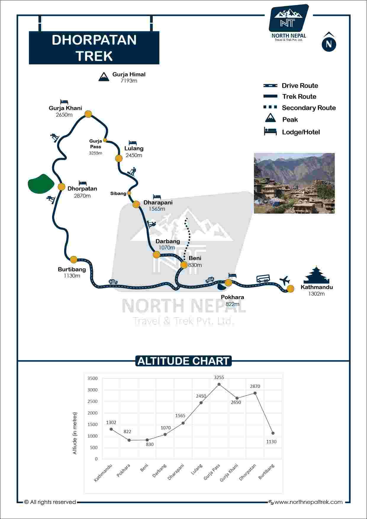
The trek follows rugged trails from Pokhara through Beni and Darbang, crossing suspension bridges, ascending through mountain passes like Gurja Pass (3,250m) and Rugachaur Pass (3,850m), and traversing Nepal's largest hunting reserve spanning 1,325 km². Trail conditions vary from bumpy jeep roads to steep uphill climbs through forests and meadows. The daily walking hours range from 6 to 9 hours. The best time to visit is the monsoon season from mid-June to September. The package includes all meals, government-licensed guides, permits, ground transportation, and achievement certificates. Go through a complete Dhorpatan packing list before you plan a trip in the monsoon.
|
Mountains seen from Jaljala
|
Height in meters
|
|---|---|
|
Mt.Putha
|
7,246 m
|
|
Mt.Gurja
|
7,139 m
|
|
Mt.Churen
|
7,371 m
|
|
Mt.Gurja
|
7,139 m
|
|
Dhaulagiri I
|
8,167 m
|
|
Dhaulagiri II
|
7,751 m
|
|
Dhaulagiri III
|
7,715 m
|
|
Dhaulagiri IV
|
7,661 m
|
|
Dhaulagiri V
|
7,618 m
|
|
Dhaulagiri VI
|
7,268 m
|
|
Annapurna I
|
8,091 m
|
|
Annapurna III
|
7,937 m
|
|
Macchapuchre
|
6,997 m
|
Mohan Raj Bhandari, Founder/Managing director
Since founding North Nepal Trek in 2015, Mohan Raj Bhandari has kept a close eye on the Dhorpatan Trek with Gurja Khani, and our senior guides shares firsthand insight from personally leading this trek, so you know exactly what to expect before you go.
Our third day is filled with beautiful scenic views from the ride to Pokhara, we will take a tourist bus to get to Pokhara from Kathmandu. Sit back and enjoy the beautiful surrounding views of the landscapes and the mountains. We will stop on the way for lunch and reach Pokhara in around 6-7 hours. We will have dinner in Pokhara and stay at a hotel in Pokhara.
Also 25 min. flight from Kathmandu Domestic terminal drops you to Pokhara. Quick & Comfort.
You will reach Takam village in 4-5 hours covering around 67 mi (107 km) distance on Darbang-Beni Road. Darbang-Beni Road plays an important role in connecting the Dhaulagiri region with Pokhara. The road to Takam follows two major towns settled on two major rivers of Nepal. One is Baglung settled on the riverside of Kali Gandaki River. Another is Beni which sits by the confluence of Kali Gandaki River and Myagdi Khola.
Takam Village is located at an elevation of 1,672 m (5,485 ft) in the Myagdi district of Gandaki Province. Sitting on the lap of the Dhaulagiri mountain ranges, Takam is home to Magar, Chhetri, Kami, and Hill Brahmin people. The majority of people are engaged in agriculture and service sectors. With the flow of tourists at Dhaulagiri Circuit Trek, the socioeconomic status of people has also changed. People are involved in Trekking Guide and Teahouse/Lodge operations.
A moderate 6–7 hour day with a consistent uphill push. Begin with a 2-hour climb to Takam Kot Mandir, a hilltop temple at roughly 1,900m with open sightlines to Dhaulagiri and Gurja Himal. From there the trail threads through oak and rhododendron forest past the hamlets of Sibang and Machhim before dropping into Muna at 1,850m.
Muna is a small Magar village where a handful of families run basic homestays. The settlement sits on a ridge above the Dar Khola valley with views down the drainage toward Myagdi. Expect dal bhat or buckwheat dishes for meals. Phone signals can be unreliable here. The village is quieter than Takam and noticeably cooler after sundown.
A demanding 5–6 hour day with a sustained climb from 1,850m toward the Deurali ridge. The trail pushes steadily into dense forest of pine, oak, and rhododendron with few flat breaks. You cross several small streams and pass seasonal herder shelters along the way. The path narrows noticeably above Muna, and trees cover things as you gain altitude.
Deurali is a simple staging point at roughly 2,400m used by herders and trekking parties moving between Muna and Deurali. Accommodation is basic — a local shelter or tented camp depending on season. Your guide will arrange meals on site. Temperatures at this elevation drop sharply after dark, so have warm layers accessible before you arrive rather than buried in your pack.
The hardest day so far. The 5–6 hour route climbs to Deurali Pass, where there is no teashop, then descends to Gurjakhani at 2,620m. Pack enough food before leaving camp. Above the treeline near the pass, Gurja Himal's 7,193m north face appears for the first time, sitting almost directly above the valley you are descending into.
Gurjakhani is a Chhantyal village and the highest permanently inhabited settlement in this corridor of the Dhaulagiri region. Around 30–40 households stay year-round, with more families returning for summer grazing. Trekkers sleep in simple family homestays. Gurja Himal fills the entire northern skyline from the village. On clear mornings, Dhaulagiri is visible to the northeast as well.
Light day after the climb to Gurjakhani. The morning hike to the viewpoint takes 2 hours up, climbing through an old Apple orchard and Rhododendron before the path opens into meadow directly below Gurja Himal's 7,193m face. Afternoon options include the old copper mines east of the village, a walk through the tight stone alleyways, or simply sitting with the mountain in front of you.

Gurjakhani's Bishwakarma community still forges tools by hand in workshops built into the stone houses. The alleyways between homes are genuinely narrow, adjacent roof slates nearly touching. Homestay meals are simple, usually rice and lentils with whatever the season offers. Chyang, a local fermented beverage prepared from Millet, is often available in the evenings if you want to try the local brew. Call it a local beer that has been relishing the locals for centuries.
The longest day of the trek — starts before 7am. The trail climbs from 2,620m to Rugachaur Pass at 3,850m, crossing three suspension bridges on the way up. Above the treeline, Dhaulagiri and Churen Himal (7,371m) open across the western skyline. The pass section is exposed and cold even in autumn. Eight hours total, with most of the elevation gain in the first four.
Rugachaur Dharmashala is a stone shelter at the edge of the Dhorpatan Hunting Reserve, used as a camp for trekking groups. Sleeping here puts you inside reserve territory by morning. Blue sheep, goral, and wolf tracks are common in the frost at this altitude. Wind picks up hard after dark. A sleeping bag rated to at least -10°C is the right call here.
A 5-6 hour descent from 3,850m to the Dhorpatan valley floor. The trail drops through Gurjaghat at 3,015m, then follows the river through pine and fir forest before the valley broadens considerably. Dhorpatan's grasslands are flat and wide — genuinely unusual at this elevation in Nepal. Pass the Bonpo Monastery at Chentung on the final approach to the main settlement.

Gurjaghat is a small waypoint where the descent eases and the trail bends toward the valley. The last section into Dhorpatan is nearly level, a welcome change after days of steep ground. Reserve headquarters is a small building cluster where trekking permits are checked on arrival. A Tibetan refugee settlement has occupied part of the valley floor since the 1960s.
No fixed itinerary today. Two main routes: hike toward Phagune Dhuri at 4,493m for the widest panorama in the reserve, roughly 4 hours up and back — or walk the valley floor to the Bonpo Monastery at Chentung, about 3 km from the main settlement. Local families also offer horse riding across the open grasslands, covering more ground than walking.

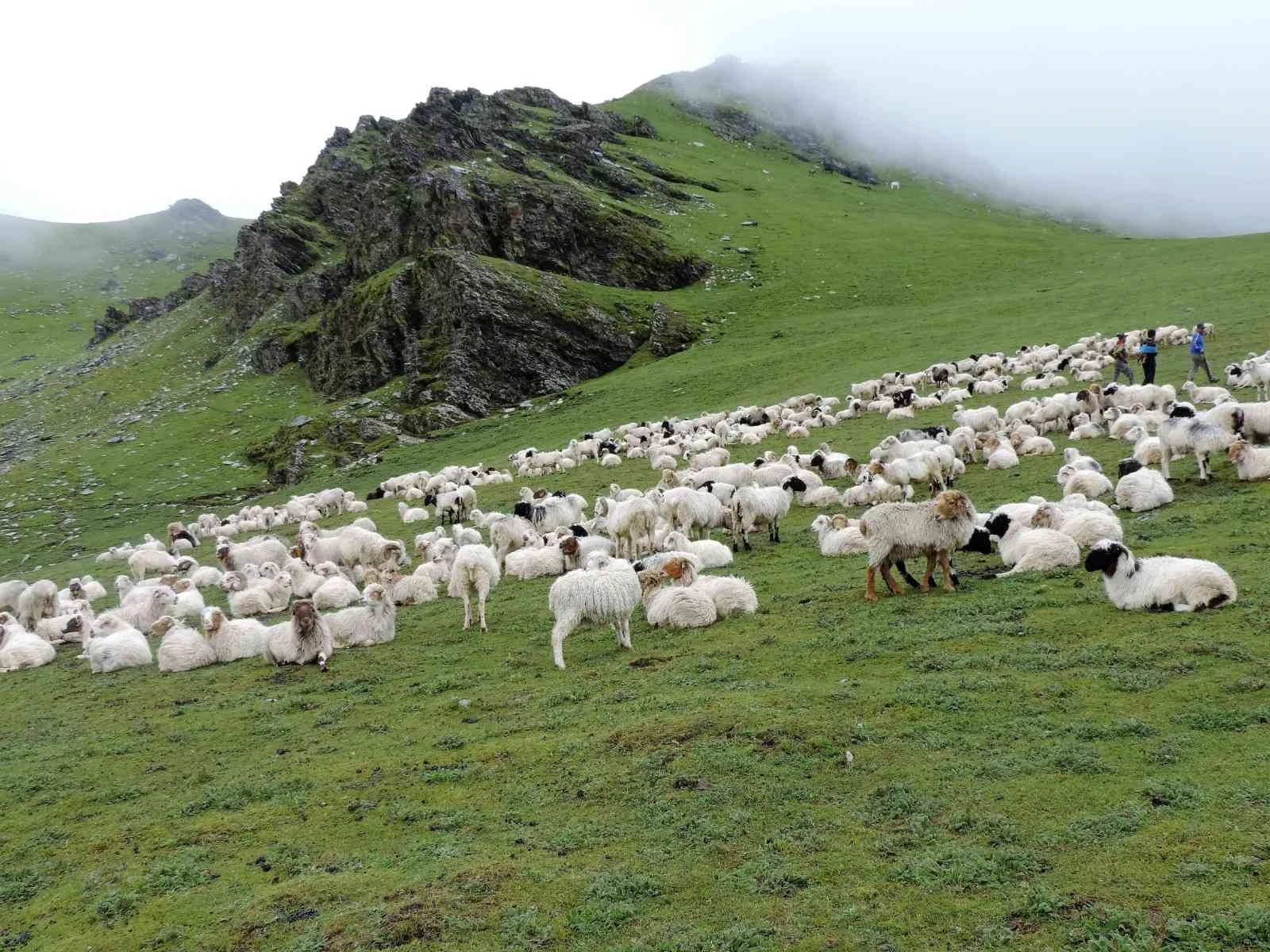
Blue sheep are the most visible large animal in Nepal’s only Hunting Reserve. Herds of 20-30 graze on open slopes above the valley and are regularly spotted from the trail. Other resident species include snow leopard, serow, goral, musk deer, and red panda. The reserve records over 137 bird species, including the Impeyan pheasant (Himalayan Monal or Danfe in Nepali), Nepal's national bird. Binoculars are recommended for birdwatchers.

The Tibetan settlement in the valley dates from the 1960s, when families resettled here after leaving Tibet. Residents maintain weaving traditions and run small tea stalls on the valley edge. The Bonpo Monastery at Chentung follows a pre-Buddhist Bon tradition still practiced across western Nepal. It is a working monastery, ask permission before entering the prayer hall.
The journey drops from the high-altitude alpine grasslands of Dhorpatan, where pine forests and distant glimpses of Dhaulagiri give way to a rugged descent. The initial leg to Burtibang consists of dusty dirt tracks carved into cliffside switchbacks, requiring a slow pace and a sturdy 4WD vehicle before transitioning onto the smoother, paved Mid-Hill Highway.
Winding east, the highway follows the roaring Myagdi Khola and Kali Gandaki river valleys, passing through bustling hubs like Beni and Baglung, famous for its massive suspension bridges. After passing Nayapul's bustling trekking trailheads and the vibrant hills of Lumle, the gorges open into Pokhara Valley, welcoming you with a sharp backdrop of Machapuchare.
You will return to Kathmandu either by taking the road or Flight. Flight gives you ample time to tour the historically and culturally rich Kathmandu Valley. You can explore UNESCO heritage sites like Pashupatinath Temple, Patan Durbar Square, and Bauddhanath Stupa. Wrap up your day by exploring local cuisines in the evening.
Your 13 days Dhorpatan Trek via Gurja Khani ends formally after boarding the flight from Kathmandu. A representative from North Nepal Trek will assist you with the necessary airport exit and bid farewell.
Because it lies in a rain-shadow zone, this trek is a good monsoon-season option (mid-June to September) when most other Nepal treks are affected by heavy rain.
Mohan was extremely accommodating and went above and beyond to help us with everything I did in Nepal. He is the go-to guy for everything and I owe many of my best experience in Nepal to him. Highly recommend this travel company. Also, shout out to Bharat who was an excellent guide!
We went to Dhorpatan hunting reserve for a two week trek with Shiva! He was our guide, he was really kind and knew a lot about the area. We felt really lucky to have such a kind and fun guide. We will be contacting Shiva again for our next adventure in Nepal.
Also, the people in the office were professional and knew a lot about the area we were travelling to. I'd recommend this company again and again to everyone.
With a maximum altitude around 4,493 m, the itinerary is paced to allow gradual acclimatization, and guides monitor trekkers daily for early signs of altitude discomfort.
This route passes through a remote hunting reserve with limited mobile coverage in places, so our guides carry satellite communication for emergencies and we require travel insurance that covers evacuation.
All trekkers must carry travel insurance covering trekking up to 4,500 m and evacuation, given the remoteness of the Dhorpatan Hunting Reserve area.
Secure the Dhorpatan Trek with Gurja Khani for 2026/2027 before the seat gets fully booked.
The Dhorpatan and Gurjakhani Trek is a moderate to strenuous trekking route through western Nepal, combining the remote landscapes of Dhorpatan Hunting Reserve with the traditional Chhantyal village of Gurjakhani. The route passes through forests, alpine meadows, mountain passes and rural settlements, with views of the Dhaulagiri range. It offers a quieter alternative to Nepal's heavily visited trekking regions.
The trek is graded moderate to strenuous. Expect approximately 5 to 7 hours of walking per day, including uneven trails, forest sections, steep climbs and high-pass crossings. Technical climbing isn't required, but good stamina and previous multi-day hiking experience are recommended.
The main route reaches approximately 3,250 m at Gurja Pass. Some alternative routes or side hikes may go slightly higher. Because the trek reaches above 3,000 m, altitude should still be taken seriously even though it doesn't reach the elevations of Everest or high Annapurna routes.
Technical mountaineering experience isn't necessary, but previous hiking or trekking experience is recommended. If you're comfortable walking uphill for several hours and have completed multi-day hikes before, the route is more manageable.
The Chhantyal are an Indigenous community of Nepal with a historical connection to copper mining. Today, many Chhantyal families are involved in farming and village-based livelihoods. Staying in Gurjakhani provides an opportunity to experience their local culture, language, traditions and hospitality directly.
Gurjakhani offers a more personal village experience than the commercial trekking routes. Staying in a local homestay allows you to interact with Chhantyal families and observe their everyday lifestyle, food traditions and community culture.
Bring broken-in trekking shoes, layered clothing, a warm down jacket, waterproof outerwear, warm socks, gloves, a hat, sunglasses, sunscreen, a reusable water bottle, headlamp and personal medication. A warm sleeping bag is particularly useful for cold nights at higher elevations.
No. The route is operated as a teahouse and homestay trek, so you don't need to carry a personal camping tent. Accommodation is provided in local homestays and basic trekking lodges along the route.
There are no ATMs along the trekking route, so you should withdraw enough Nepalese Rupees in Kathmandu or Pokhara before departure. The source recommends approximately NPR 15,000 to 20,000 in small denominations for personal expenses, drinks, boiled water, charging where available and tips.
Personal expenses aren't generally part of the trekking package. Budget for additional drinks, hot tea, boiled water, charging where available, snacks and tips for your guide and porter. Carrying sufficient cash is important because card payments and ATMs aren't available once you're on the trail.
The supplied source recommends trekking with an experienced local guide because the route is remote and sections are poorly marked. It also notes that current Nepal trekking regulations should be checked when booking, as the rules governing independent trekking have changed in some protected areas.
The route can be adjusted around your fitness, available time and trekking interests. Additional days can be considered where accommodation and local logistics allow.
The route has different advantages in different seasons. Spring and autumn generally offer more stable trekking conditions and clearer mountain views. The monsoon period can also be attractive around Dhorpatan, when the alpine meadows become particularly green and wildflowers are abundant, but wet trails and leeches become more likely in forested sections.
Even when daytime temperatures are comfortable, nights can become close to freezing, particularly at higher elevations. A good down jacket, warm layers and a suitable sleeping bag are important for spring and autumn departures.
They can appear during the monsoon season and after heavy rainfall, particularly in forested areas. During the drier spring and autumn periods, leeches are much less common.
The risk is lower than on routes reaching 4,500 m or higher, but altitude-related symptoms can still occur because the route crosses passes above 3,000 m. Walk at a steady pace, stay hydrated and tell your guide immediately if you develop a persistent headache, dizziness, nausea or unusual fatigue.
The route doesn't require technical climbing, but its remote character and uneven terrain make it more demanding than a short beginner trek. Trekkers should be comfortable with several hours of walking each day and should travel with appropriate preparation and local support.
Don't drink water directly from streams or untreated taps. Use water purification tablets, a suitable filter or UV treatment, or drink boiled water available at homestays and lodges.
You need a Dhorpatan Hunting Reserve Entry Permit to enter the reserve. North Nepal Travel & Trek can arrange the required permit before the trek begins.
The route normally begins with a road journey from Kathmandu or Pokhara toward Beni and Darbang, where the trekking section begins. Private 4WD jeeps are used for the mountain-road sections because road conditions can be rough in places.
This is primarily a teahouse and homestay trek. In Gurjakhani, you'll stay in a local family homestay, while other sections use basic trekking lodges. Facilities are simple, with no expectation of heated private rooms or hotel-style amenities.
Dal Bhat, made with rice, lentils and vegetables, is a reliable staple along the route. You can also find simple noodles, flatbreads and eggs. Local vegetarian meals are a practical choice because ingredients are generally sourced locally and prepared fresh.
Mobile coverage from NTC and Ncell is patchy and becomes increasingly unreliable away from the main towns. You should expect sections of the trek with little or no mobile connectivity.
Reliable Wi-Fi shouldn't be expected. Higher villages such as Gurjakhani have very limited or virtually no Wi-Fi, making this a route where you should be prepared to spend several days largely offline.
Clear-weather views include the Dhaulagiri range, Gurja Himal, Churen Himal and Putha Hiunchuli. The higher passes provide particularly impressive perspectives of the surrounding snow-covered peaks.
Yes. The reserve is known for its Himalayan wildlife, and trekkers may encounter animals in their natural habitat. However, hunting activities are controlled and take place in designated areas and seasons away from the main trekking route. Visitors shouldn't expect to see hunting activities during a normal trek.
The route combines dense forests, alpine meadows, remote villages, high passes and Dhaulagiri mountain scenery in one journey. Its relatively low visitor numbers are a major part of the experience, particularly for trekkers looking for a quieter alternative to the established Annapurna and Everest routes.