Nar Phu Valley: The Complete Guide to the Trek, the Villages and Kang La Pass
Published Nov 16, 2026 Updated Nov 18, 2026 12 min read
Quick answer
Nar Phu is a restricted valley in Manang, north of the Annapurna Circuit. Our 10-day trek walks from Koto to Phu and Nar and crosses Kang La, 5,320 m (17,454 ft), to Ngawal. It needs a permit and licensed guide.
I send guests into this valley every autumn and spring, and it is the trek I suggest to people who loved the Annapurna Circuit but want fewer lodges, fewer people and more village life. Past Koto the jeep road ends. You walk up a narrow gorge, out onto open yak pasture and into two stone villages that only opened to trekkers in 2003. This guide brings together everything we know about the valley: where it is, who lives there, how the route works, what it costs, and when to go. Each section links to a deeper guide when you want more.
Key facts
WhereNarpa Bhumi Rural Municipality, Manang district, Gandaki Province
Main villagesPhu, 4,110 m (13,484 ft); Nar, 4,110 m (13,484 ft)
Highest pointKang La Pass, 5,320 m (17,454 ft)
Our trek10 days, 7 walking days, about 71 to 80 km
GradeChallenging
Best monthsOctober, then April and May
PermitsRestricted Area Permit and ACAP; a licensed guide is required
Price with usFrom USD 1,200 per person for two people
Where is Nar Phu Valley?
Nar Phu Valley lies in Manang district, in the high country between the Annapurna and Manaslu ranges, just south of the Tibet border. Its river, the Phu Khola, joins the Marsyangdi at Koto on the Annapurna Circuit, and that is where every trek begins.
The valley sits behind the main Annapurna wall, so it is far drier than the forests you drive through to reach it. Within a day of Koto the pine trees thin out and the land turns to brown scree, juniper and yak pasture, much like Upper Mustang. Peaks stand all around: Annapurna II, Pisang Peak and Kang Guru from the lower valley, and Himlung Himal above Phu.
Administratively the valley is Narpa Bhumi Rural Municipality. For the full picture of the gorges, rivers, passes and peaks, with our altitude profile, read our Nar Phu Valley map and geography guide.
Phu, Nar and the places in between
Two villages give the valley its name, Phu at the head of the valley and Nar on a ridge above its own side valley. Between them and Koto are a handful of seasonal settlements where you will stop for lunch or the night.
Place
Height
What it is
Koto
2,600 m (8,530 ft)
Annapurna Circuit village and the checkpoint where the restricted area starts
Meta
3,560 m (11,680 ft)
A winter settlement and overnight stop with a handful of simple lodges
Chyakhu
3,500 m (11,483 ft)
Small settlement and lunch stop, with ruins from the Khampa period nearby
Kyang
3,840 m (12,598 ft)
Fields and winter houses used by the people of Phu
Phu
4,110 m (13,484 ft)
Stone village on a hill above the Phu Khola, home of Tashi Lhakhang gompa
Nar Phedi
3,490 m (11,450 ft)
A monastery where trekkers sleep, below Nar
Nar
4,110 m (13,484 ft)
The larger village, barley fields, gompas and chortens; the start of the Kang La climb
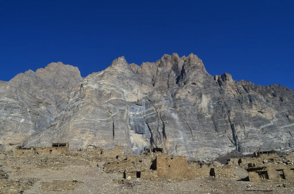
Phu is the more dramatic of the two. Its 30 to 40 stone houses are built one on top of another on a fortress-like hill, and you enter through an old gate above the river gorge. Nar is bigger and greener, with terraced barley fields, painted chortens and a long view of Kang Guru and Pisang Peak. Our guide to the villages and culture of Nar and Phu walks through both.
The stone houses of Phu, 4,110 m (13,484 ft), at the head of the valley. Photo: North Nepal Travel & Trek.
A short history of the valley
People have farmed and herded in Nar and Phu for centuries, and the valley stayed closed to trekkers until 2003. Villagers trace their ancestry to Tibet, and for generations they traded with Manang and Chame further down the Marsyangdi.
Nepali Times described the valleys in 2005 as high, arid country that Bhotia people, Tibetan-speaking highlanders, had inhabited for many centuries. Exactly when the first families arrived is not settled, and you will hear different answers in the villages themselves.
In the 1960s and early 1970s the Tibetan resistance fighters known as Khampas used remote corners of the Mustang and Manang borderlands as bases, and our guides point out ruins near Chyakhu that local people link to that time. The valley opened to trekking in 2003, and Nepali Times reported 244 permits issued in 2004. Today a jeep road reaches Koto, solar panels sit on Phu's roofs, and many younger people live part of the year in Kathmandu. Read more in our short history of Nar and Phu, and in our story on the Khampa rebellion along the Tibet border.
Culture, language and the valley rules
Nar and Phu are Tibetan Buddhist communities with their own language, Nar-Phu, now spoken by only a few hundred people. From Meta onwards the valley asks visitors not to eat meat, drink alcohol or smoke.
Language researchers describe Nar and Phu as two closely related, mutually understandable varieties of one Tibeto-Burman language. A documentation project in 2011 estimated fewer than 400 speakers in Nar and about 200 in Phu, most of them over fifty, and called the language moribund because young people now grow up in Kathmandu or abroad. You will hear it in the lodges and fields, mixed with Nepali.
The gompas are the centre of village life. Phu's Tashi Lhakhang is the best known, and accounts of who founded it differ, so ask the lama when you visit. Nar has its own gompas among the fields, and at Nar Phedi you sleep inside a working monastery and can join the evening puja.
The no-meat, no-alcohol, no-tobacco custom comes from the valley's rule against killing animals. It is vegetarian, not vegan: yak curd and yoghurt are on most menus. Plan around it, and leave the beer for Manang. Our villages and culture guide covers etiquette in the gompas and villages.
Our 10-day route at a glance
Our standard trek takes 10 days from Pokhara or Kathmandu: one day in by road, seven walking days with a rest day at Phu, a crossing of Kang La, and one long drive out from Manang.
Day
Route
Sleep at
Distance and time
1
Pokhara or Kathmandu to Besisahar by road, then jeep to Koto
Koto, 2,600 m (8,530 ft)
9 to 11 hours of driving
2
Koto to Meta
Meta, 3,560 m (11,680 ft)
13 to 14 km, 6 to 7 hours
3
Meta to Kyang via Jhunam and Chyakhu
Kyang, 3,840 m (12,598 ft)
10 to 11 km, 4 to 5 hours
4
Kyang to Phu
Phu, 4,110 m (13,484 ft)
9 to 10 km, 3 to 4.5 hours
5
Rest day at Phu: Himlung Base Camp hike if conditions allow, or a village walk
Phu
18 to 20 km, 6 to 7 hours; or 3 to 5 km, 2 to 3 hours
6
Phu to Nar Phedi
Nar Phedi, 3,490 m (11,450 ft)
12 to 13 km, 4.5 to 6 hours
7
Nar Phedi to Nar
Nar, 4,110 m (13,484 ft)
4 to 5 km, 2 to 3 hours
8
Nar over Kang La (5,320 m) to Ngawal
Ngawal, 3,650 m (11,975 ft)
15 to 17 km, 8 to 10 hours
9
Ngawal to Manang
Manang, 3,519 m (11,545 ft)
8 to 10 km, 3 to 4 hours
10
Jeep from Manang to Besisahar, then road to Pokhara or Kathmandu
-
11 to 13 hours; the jeep leaves at 05:30
The full day-by-day notes, inclusions and departure dates are on our Nar Phu Trek, 10 Days package page.
How hard is the Nar Phu trek?
The Nar Phu trek is challenging. Most days are steady, but Day 2 gains 960 m and the Kang La day is 8 to 10 hours with about 1,210 m up and 1,670 m down. Previous walking at altitude helps a lot.
Day 2 is the one people underestimate. Koto to Meta climbs from 2,600 m to 3,560 m in one go, well beyond the Wilderness Medical Society advice to sleep no more than 500 m higher each night at this altitude. Walk slowly and drink well. If someone is struggling, we can split the day at Singenge Dharamsala, 3,230 m (10,597 ft).
The middle of the trek is kinder. Days 3 and 4 add under 300 m each, the rest day at Phu lets you hike high and sleep low, and Day 6 drops you to Nar Phedi at 3,490 m before the climb to Nar. Then comes Kang La: a pre-dawn start, steep scree to the top, and a long descent on loose rock to Ngawal. Our Kang La Pass guide covers that day hour by hour, and our guide to altitude sickness in Nepal explains the warning signs.
Heads up
There is no water source on the trail between Koto and Meta, and Day 2 is the longest climb of the trek. Fill two litres before you leave Koto, and start early. In late autumn Kang La can be shut by snow for days at a time, so keep a spare day and be ready to walk back down the valley to Koto if the pass is closed.
Permits and the guide rule
You need a Restricted Area Permit and an ACAP permit, arranged by a registered agency, and a licensed guide must walk with you. Since 22 March 2026 a solo trekker can get the permit. TIMS is not required.
The Restricted Area Permit for Manang costs USD 100 per person for the first week from September to November and USD 75 from December to August, plus USD 15 for each extra day. ACAP is NPR 3,000, about USD 19 at mid-October 2026 rates. We arrange both and they are included in our price. Our Nar Phu permit guide explains the details, and our solo restricted-area guide covers what changed in 2026.
What the trek costs in 2027
Our 10-day Nar Phu trek costs USD 1,200 per person for two people, falling to USD 1,030 each for 13 to 25. That covers permits, a licensed guide, lodges, three meals a day and road transport.
On top, budget for your flights, Nepal visa, travel insurance that covers trekking to at least 6,000 m with helicopter evacuation, tips, and paid extras on the trail such as charging, hot showers and Wi-Fi. There are no ATMs in the valley, so carry Nepali rupees from Pokhara or Kathmandu. Every line of the budget is in our Nar Phu trek cost guide for 2027.
Where you sleep and what you eat
You sleep in simple teahouses in Meta, Kyang, Phu and Nar, and in the monastery at Nar Phedi. Rooms are basic twins with shared toilets, and menus are short and vegetarian: dal bhat, thukpa, momos, potatoes, eggs and soup.
The lodges get simpler the further up the valley you go, and blankets are thin, so a warm sleeping bag matters. Our package includes one. Charging runs on solar power and costs around NPR 100 to 200 a time, and phone signal fades once you leave Koto. Our Nar Phu teahouses and food guide goes night by night.
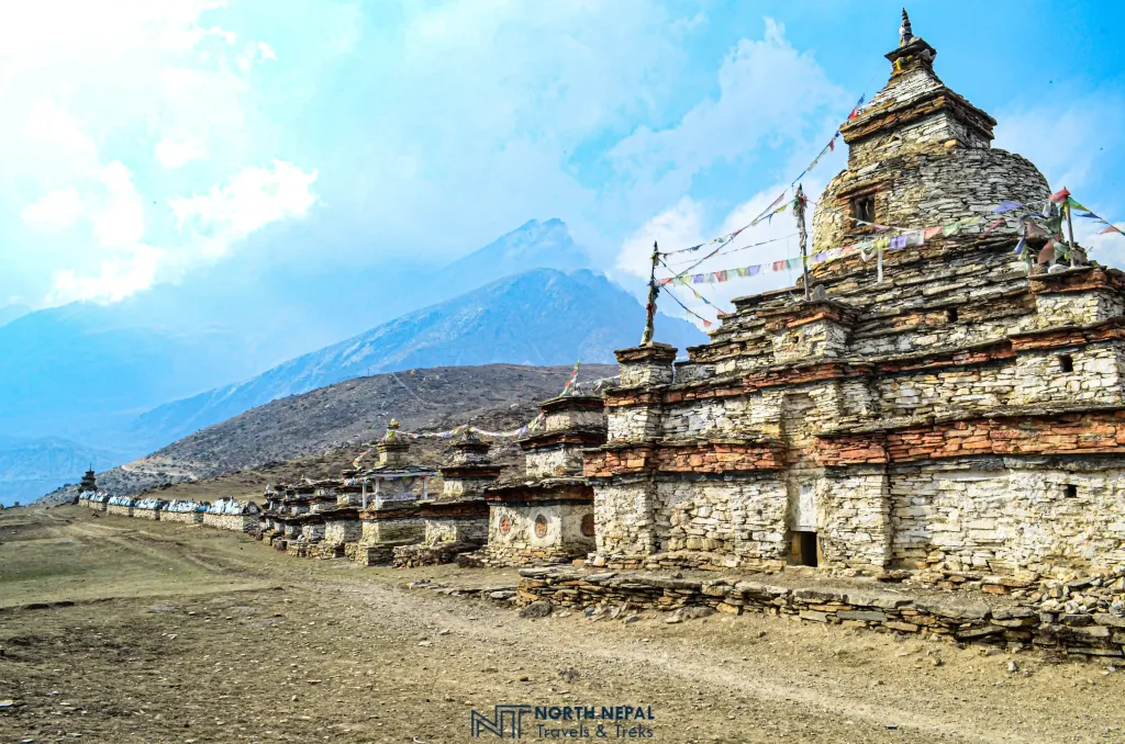
A line of chortens on the climb from Nar Phedi to Nar. Photo: North Nepal Travel & Trek.
When to go
October is the most reliable month for Nar Phu, followed by April and May. November is clear but colder, with a growing chance of snow closing Kang La. Winter is extreme, and the summer monsoon is drier here than elsewhere but makes the road to Koto slow.
The 2026 autumn showed why spare days matter: snow from 24 to 27 September blocked Thorong La on the neighbouring Annapurna Circuit until 5 October, and a cyclone at the end of October brought heavy snow warnings to the Manang Himalaya. Our best time for Nar Phu in 2027 guide goes month by month, and our October 2026 snow warning shows how fast conditions change.
Combining Nar Phu with other treks
Because Kang La drops you at Ngawal on the Annapurna Circuit, Nar Phu joins naturally onto the Circuit, Thorong La and Tilicho Lake. It adds about a week. If you are choosing between restricted areas, Upper Mustang is its closest rival.
After Nar Phu you are very well acclimatised for Thorong La (5,416 m, 17,769 ft), which makes the combination a natural choice if you have the extra days. Read how to combine the Annapurna Circuit with Nar Phu, and our comparison of Nar Phu and Upper Mustang.
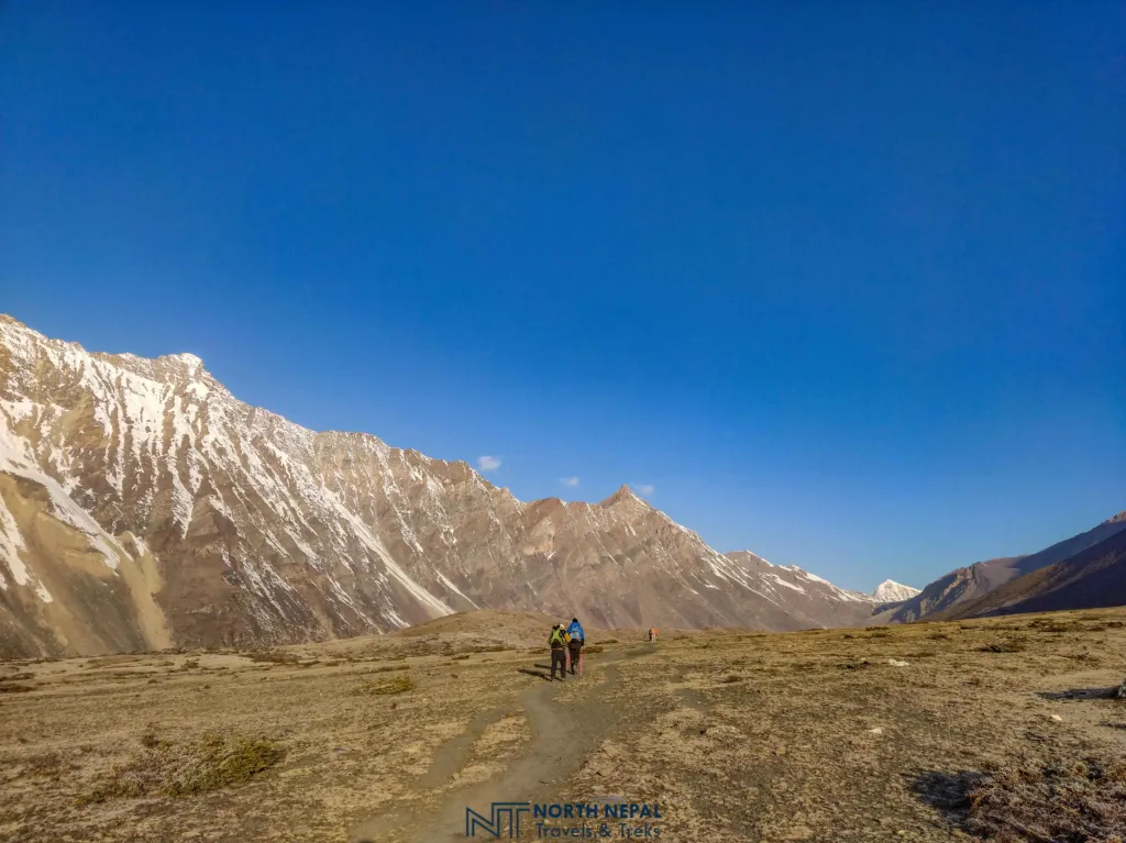
Two of our trekkers on the way to Kang La, 5,320 m (17,454 ft). Photo: North Nepal Travel & Trek.
Frequently asked questions
Nar Phu Valley is in Manang district, Nepal, north of the Annapurna Circuit and close to the Tibet border. The trail starts at Koto on the Circuit and the valley is part of the Annapurna Conservation Area.
Our standard trek is 10 days from Pokhara or Kathmandu, with seven walking days and a rest day at Phu. Keep one spare day in autumn in case snow closes Kang La.
Phu and Nar villages both sit at 4,110 m (13,484 ft) on our itinerary. The highest point of the trek is Kang La Pass at 5,320 m (17,454 ft).
No. Nar Phu is a restricted area, so a licensed guide booked through a registered agency must walk with you. Since 22 March 2026 one trekker can get the permit alone, but the guide is still required.
No. If the pass is closed or you would rather not cross it, you can walk back down the valley from Nar to Koto. You miss Ngawal, but it is the safe choice on a bad day.
The Nar Phu trek is shorter but rougher. Kang La (5,320 m) is slightly lower than Thorong La (5,416 m), but the lodges are simpler, the Day 2 climb is steeper and you are further from help.
No. From Meta onwards the valley is a no-meat, no-alcohol and no-tobacco zone. Lodges serve vegetarian food, eggs, and yak curd and yoghurt.
Signal is poor or absent in Phu, Nar and on Kang La. Charging is solar and costs around NPR 100 to 200. Bring a power bank and tell family you may be out of touch for several days.
Department of Immigration fee schedule as published by TAAN, "Trekking permit fees" (Manang: Narpa RM wards 1 to 5, Nasho RM wards 6 and 7), accessed 18 November 2026: https://taan.org.np/page/trekking-permit-fees
North Nepal Travel & Trek, Nar Phu Trek 10 Days package page and Nar Phu itinerary verification (house heights, day distances and times confirmed by Mohan on 16 and 18 November 2026)
A native of the Annapurna region, he brings over 17 years of firsthand experience leading treks across the mountains of Nepal. His deep local roots and proven guiding expertise make him a trusted authority on authentic Himalayan adventures.