Everest From the Top: What the Summit Really Looks Like
Published Oct 26, 2026 Updated Oct 26, 2026 7 min read
Quick answer
The top of Mount Everest is a snow dome of about 30 sq ft (2.8 m²), covered in prayer flags. Climbers there look down on Lhotse, Makalu and Cho Oyu, and across Nepal to the south and Tibet to the north.
I haven't stood on the summit of Everest myself. I have stood on Kala Patthar with our guests looking up at it, and the question that always comes is: what is it actually like up there? This post puts together what summiteers, surveyors and scientists have recorded about the top, and what you can see of it without a climbing permit.
Key facts
Summit height8,848.86 m (29,032 ft), Nepal–China survey, December 2020
Summit sizeAbout 30 sq ft (2.8 m²), a small snow dome
Peaks below youLhotse 8,516 m · Makalu 8,485 m · Cho Oyu 8,188 m
South Col to summitAbout 1.7 km (1.07 miles), usually 6 to 9 hours
Usual summit timeEarly morning, after leaving the South Col before midnight
Highest weather station8,810 m (28,904 ft), installed May 2022
Closest trekker viewKala Patthar, 5,644 m (18,517 ft)
What does the top of Mount Everest look like?
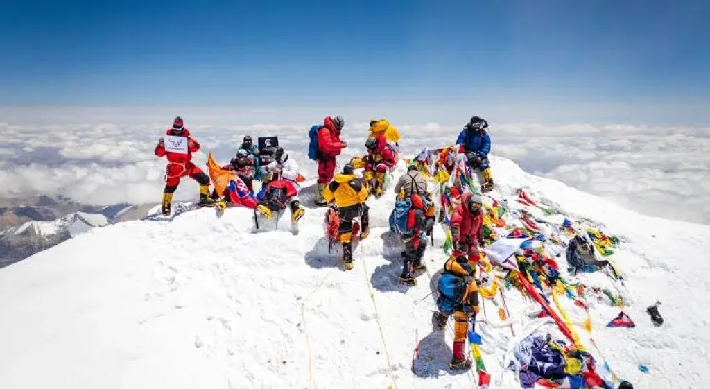
The summit is a small, rounded dome of snow and ice, not a rock point. Alan Arnette, who summited in 2011, describes it as "maybe 30 square feet", about 2.8 m², with a small bench cut into the snow where climbers sit for photos.
Prayer flags cover it, left by climbing teams over many seasons, and on a busy morning it is crowded with climbers waiting for their photo. The height of that snow surface is 8,848.86 m (29,032 ft), the figure Nepal and China announced together on 8 December 2020 after Nepal's 2019 survey and China's 2020 survey.
A busy summit morning on Everest. When a weather window opens, most teams try to use the same few days.
What can you see from the summit of Everest?
Every other mountain is below you. Lhotse, 8,516 m (27,940 ft), rises just to the south, Makalu, 8,485 m (27,838 ft), to the south-east and Cho Oyu, 8,188 m (26,864 ft), to the west-north-west. To the north is the brown, high Tibetan plateau, and to the south the valleys of Nepal, often hidden under morning cloud.
The horizon is a few hundred kilometres away, but you won't clearly see the Earth curve. A 2008 study by the physicist David Lynch put the lowest height at which the curve can be seen at about 35,000 ft (10,600 m), higher than Everest, and that is with a wide view and an almost cloudless sky.
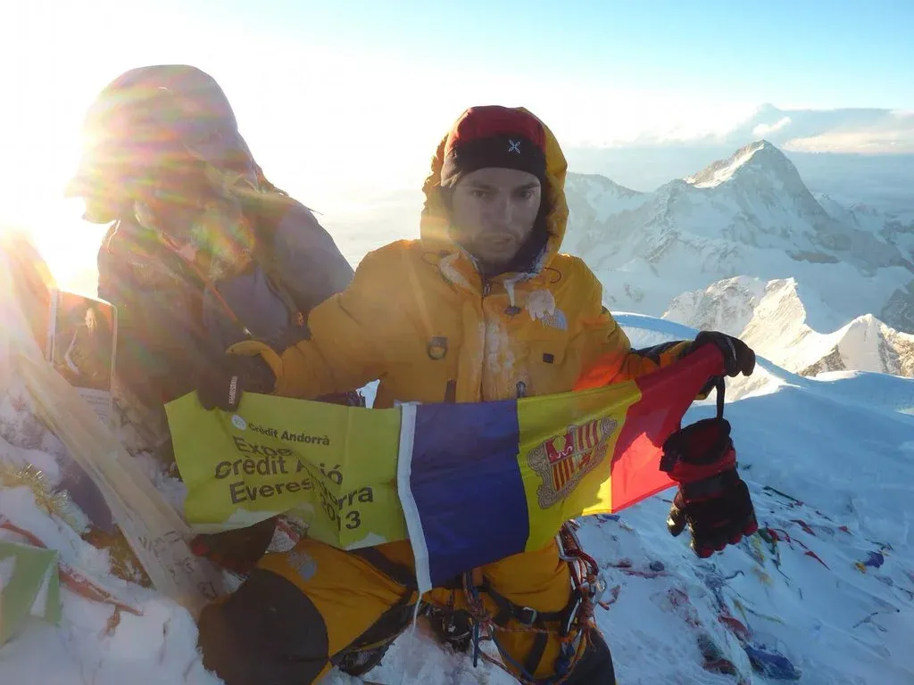
Domi Trastoy on the summit of Everest on 22 May 2013, the first Andorran to reach the top, with lower peaks behind. Photo: Domi Trastoy, Wikimedia Commons, CC BY-SA 4.0.
What is the last stretch to the summit like?
On the Nepal side, summit day starts at the South Col, usually before midnight, and covers about 1.7 km (1.07 miles) to the top. Arnette puts it at 6 to 9 hours or more on the way up, and 9 to 18 hours for the round trip. Climbers reach the Balcony at about 8,400 m (27,559 ft) in the dark, then follow the Southeast Ridge to the South Summit.
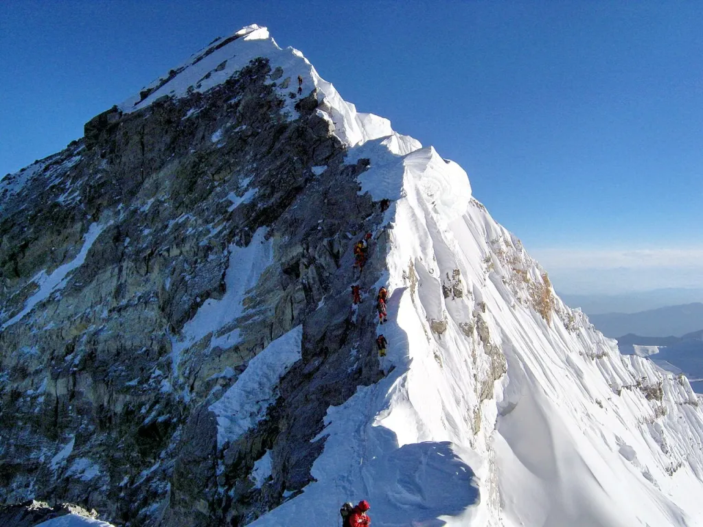
From the South Summit the route drops a little, crosses the Cornice Traverse, a knife-edge ridge Arnette calls the most exposed part of the climb, and reaches what was the Hillary Step, a rock step of about 12 m (40 ft). In May 2017 the British climber Tim Mosedale reported that the step had collapsed, probably in the 2015 earthquake. In May 2018 Kenton Cool told AFP that climbers now go "up a snow slope" on the right, and the Nepali guide Dawa Phinjo Lama Bhote said a block of about 5 m (16 ft) had gone. Nepal's tourism department said it had heard of no change. After the step, a short snow ridge leads to the top.
The final ridge of Everest above the South Summit, photographed in 2010, before the Hillary Step changed. Photo: Debasish Biswas (retouched by MagentaGreen), Wikimedia Commons, CC BY-SA 4.0.
How long do climbers stay on top, and why so short?
Usually only minutes. Every hour above 8,000 m (26,247 ft) uses bottled oxygen, daylight and strength that climbers need for the descent, and Arnette warns that the descent is the riskiest part of summit day.
The cold and wind are the other reasons. In May 2022 a team installed the world's highest weather station at 8,810 m (28,904 ft), 39 m below the summit. On the morning they worked, the wind was 64 km/h (40 mph) and the wind chill about −40 °C (−40 °F). Most climbers take their photos, call their team on the radio and turn round.
Heads up
A summit photo with a flag and blue sky is the end of a night of climbing, taken in a few hurried minutes. Climbers are on bottled oxygen, behind goggles and thick gloves, and short of time. If you want to look at Everest properly, a trekker on Kala Patthar at sunrise often sees more of it than a climber on top.
Can you see the top of Everest without climbing?
Yes, from below. The best walking viewpoint on the Nepal side is Kala Patthar, 5,644 m (18,517 ft), on our 12-day Everest Base Camp Trek. From there the summit pyramid is in front of you, with the Southwest Face below it and the summit ridge on its right. You can't see the summit from Everest Base Camp itself, because Nuptse hides it.
Gokyo Ri, 5,357 m (17,575 ft), on the Gokyo Lake Trek, shows Everest from the west above the Ngozumpa Glacier. If you have only a day, the Everest Helicopter Tour flies you up the Khumbu for a close look from the air. Helicopters fly only when the weather allows, so keep a spare day in your plans.
Our post on the faces of Everest explains which side of the mountain you are looking at from each viewpoint.
Our trekkers looking at Everest from the Kala Patthar side, the closest a trekker gets to the summit view. Photo: North Nepal Travel & Trek.
Frequently asked questions
Snow and ice. The summit is a small snow dome, about 30 sq ft (2.8 m²) by Alan Arnette's estimate, with a bench cut into the snow for photos, and it is usually covered in prayer flags.
8,848.86 m (29,032 ft), the height Nepal and China announced together on 8 December 2020. It is measured to the snow surface on the summit.
Lhotse, Makalu and Cho Oyu, all lower than you, with the Tibetan plateau to the north and the valleys of Nepal to the south. Morning cloud often hides the valleys below.
No, not clearly. The horizon is a few hundred kilometres away, but a 2008 study by David Lynch put the lowest height for seeing the curve at about 35,000 ft (10,600 m), higher than Everest, with a wide, almost cloudless view.
Not as it was. In May 2017 the climber Tim Mosedale reported that the rock step, about 12 m (40 ft) high, had collapsed, probably in the 2015 earthquake, and in 2018 climbers told AFP they now go up a snow slope on its right. Nepal's tourism department said it had heard of no change.
Usually only minutes. Climbers need their oxygen, daylight and energy for the descent, which is the riskiest part of summit day, and the summit is often very cold and windy.
Climb Kala Patthar, 5,644 m (18,517 ft), on the Everest Base Camp trek, or Gokyo Ri, 5,357 m (17,575 ft), on the Gokyo trek. A helicopter tour gives an aerial view in a single morning when the weather is clear.
A native of the Annapurna region, he brings over 17 years of firsthand experience leading treks across the mountains of Nepal. His deep local roots and proven guiding expertise make him a trusted authority on authentic Himalayan adventures.