Teri La Pass Trek - 20 Days

Teri La Pass Trek - 20 Days
DESTINATION Nepal
MAX. ELEVATION 5,577 m|18,297 ft
WALKING DISTANCE ~180 km
GRADE Challenging
BEST SEASON Spring & Autumn
DURATION 20 Days
MEALS INCLUDED Breakfast, Lunch & Dinner
ACCOMMODATION Lodge and Camping

OVERVIEW & HIGHLIGHTS

Overview the Teri La Pass Trek

The 20-Day Teri La Pass package is the longest and an off-the-beaten-path adventure offered by North Nepal Trek. The walk is through the restricted corridors of the Nar-Phu Valley & Upper Mustang. This challenging route offers a dramatic trans-Himalayan rain shadow, connecting the old Tibetan-Buddhist settlement of Manang to the "Forbidden Kingdom" of Lo. To enter, three permits are required: an ACAP, a Nar-Phu RAP, and the Upper Mustang RAP, all managed by us.

The trail shifts from the lush Annapurna foothills into isolated, windy valleys and sedimentary cliffs. This trek offers a glimpse into a remote landscape, ancient Gompas, a clustered settlement of locals at Nar-Phu, and the astonishing Upper Mustang valley. The trek culminates at the Teri La Pass (5,577m / 18,297 ft), a high-altitude "bridge" offering 360-degree views across the Damodar Himal and the arid Tibetan Plateau, eventually descending into the walled capital of Lo Manthang.

Why you will love the Teri La Pass Trek?

  • Chance to explore the remote side of Upper Mustang
  • Experience the well-preserved local culture & lifestyle of Tibetans
  • Opportunity to explore the Lo-Manthang along with the deepest gorge, Kali Gandaki
  • A different picturesque view of the snow-capped mountains in desert-like landscapes
  • The comparatively less crowded trekking route with a few small settlements and locals en route
  • One of the major reasons to love the Teri La Pass Trekking Adventure is due to the Teri La Pass itself. Reaching the Teri La Pass is itself a rewarding achievement for the trekkers.
Uttam Pun
Itinerary review by

Uttam Pun, Trekking Guide

Teri La Pass Trek route and pacing are drawn from 12+ years guiding the Annapurna region. Mohan founded North Nepal Trek in 2015; this itinerary has been reviewed by Uttam Pun, one of our government-licensed local guides.

Teri La Pass Trek Itinerary

Toggle all
Day 1

Drive from Kathmandu|PKR to Besisahar

HIGHEST ALT. 2620 m | 8,596 ft
Distance
DISTANCE 175 km |80 km

On the first day, the representatives from North Nepal Travels and Treks will pick you up from the hotel. After that, we will drive from Kathmandu to Besisahar in a comfortable tourist bus with huge leg space. Besisahar is 175.1 km far from Kathmandu and it takes about 5 hours from Kathmandu, and 80 km from Pokhara. We start the drive early in the morning through the Prithivi Highway, this route takes us through several towns, rivers, waterfalls, and settlements. You can get views of the pristine Marsyangdi River and the hydropower installations.

From Besisahar, we take a private jeep to complete this section of the Teri La Pass Trek. it takes another 5 to 6 hours to reach Koto. Therefore, the total driving time for this day is between 9 to 10 hours. Besides, this section of the drive takes us past different significant villages like Syange, Jagat, Chamje, Dharapani, Timang, and Danakyu. In Dharapani, we stop for lunch before continuing further to reach Koto.

Koto is a beautiful village in this trekking region where the trekkers can immerse into the wilderness of nature and interact with the locals living here. If the trekkers have enough time, trekking to Koto from Besisahar is also a good idea. However, let us tell you that Besisahar to Koto is a 4 to 5-day trekking journey. So, your package days will significantly increase if you choose the trek from Besisahar to Koto.

Day 2

Trek from Koto to Meta

HIGHEST ALT. 3560 m | 11680 ft
DURATION 7 hrs
Distance
DISTANCE 14 . 5 km

Our walking journey begins on the third day as we ascend from Koto to Meta. As the trekkers have their breakfast in Koto, our guides lead you on a 7-hour-long hike to Meta. We need to cover an approximate distance of 14.5 km to reach Meta from Koto and the route also separates from the Annapurna Circuit Trek. Moreover, this section of the trek to Teri La Pass also experiences a significantly lower number of trekkers.

As we begin the journey from Koto, trekkers need to get their restriction area permits for the Teri La Pass trek and Nar Phu Valley trek checked in a police check post just as we exit this village. After that, the route continues and enters the Nar Valley as we cross the suspension bridge over the Marsyangdi River. Furthermore, we walk by the Nar River and Soti Khola and also pass through a lush pine and oak forest. Remember that, throughout the Teri La Pass, we need to cross several forests and rivers. Moreover, we also walk on multiple suspension bridges and deep river gorges.

Before reaching Meta, this section of the Teri La Pass Trek journey also stops by another lovely village named Dhramashala. This village arrives just two hours before we reach Meta. Reaching Meta completely changes the surroundings as the trekkers can find themselves standing on a Tibetan plateau while watching the most scenic views of Lamjung Himal and Annapurna II.

Dinner and Overnight stay will be arranged by North Nepal Treks and Travels.

Day 3

Ascend from Meta to Kyang

HIGHEST ALT. 3820 m | 12533 ft
DURATION 4 - 5 hrs
Distance
DISTANCE 6 km

As you wake up and have your breakfast early in the morning, our trekking guides will take you on another walking journey in the Teri La Pass Trekking itinerary. This section of the trek is not very difficult and trekkers can also get chances to watch the yaks and other cattle grazing. Witnessing the mountains, walking above the gorges, and taking some amazing glimpses of nature's beauty, we go from Meta to Kyang.

Trekkers from North Nepal walking along the route of Kyang Village during Teri La Pass Trek.
Photo: Kyang Village

As we reach the altitude of 3820 meters above sea level, this is where Kyang sits. Such an amazing settlement where people from higher reasons shift during the excessive snowfall in the winter season. People shift along with their cattle and make temporary houses to live in throughout the winter season. Besides, from this village, we can also get some amazing glimpses of mountain peaks, including, Annapurna II, Annapurna IV, Lamjung Himal, etc.

The people living here offer warm hospitality and you also get to taste some of the delicacies prepared with yak milk. Another amazing thing to witness in the Kyang settlement is the huge rocky mountains with unique structures. Also, these hills go deep down to form gorges.

We will spend a night in a tent after having dinner.

Day 4

Trek from Kyang to Phu Gaun

HIGHEST ALT. 4,250 m | 13,944 ft
DURATION 5 - 6 hrs
Distance
DISTANCE 8 km

The route from Kyang to Phu Gaun is designed differently as it is designed by craving a huge stone and the path passes through the stone. This trail starts just 5 minutes before we leave Kyang after having breakfast and extends for almost 1.5 kilometers.

Phu Village with old stone houses captured by North Nepal Trek during Teri La Pass TrekPhoto: Phu Village

As the path passes through the middle part of the huge rock, it is narrow and goes just beside the deep Nar River Gorge. Moreover, we will also come across several landslide-prone areas during this section of the Teri La Pass Trek route. Therefore, we recommend all trekkers be very mindful and cautious while trekking from Kyang to Phu Gaun.

Talking about Phu Gaun, this village is known as a deserted settlement because vegetation and greenery are significantly low in this place. However, people still live here and you can also meet and interact with them as you reach the Phu Gaun.

We will spend the night here in Phu Gaun after having a fulfilling breakfast.

Day 5

Rest or Acclimatization Day in Phu Gaun

HIGHEST ALT. 4900 m | 16,080 ft
DURATION 5 - 6 hrs
Distance
DISTANCE 9 km

As we have already ascended to an altitude of 4250 meters above sea level, our body requires some rest and time to adapt to the climate and weather. Therefore, on the fifth day, we will have an acclimatization day in Phu Gaun.

This village is very beautiful and offers some magical glimpses of the Himalayas, valleys, deserted lands, and rocky hills. Moreover, you can also interact with the locals and try some of the unique delicacies they prepare. Besides, the locals in this village follow a traditional way of farming and vegetation. Furthermore, Phu Gaun also consists of several Gumpas and monasteries which can be explored in the acclimatization day itself.

Other than that, if the trekkers have energy and want to go for some adventures, our guides can also take you on some short hikes like a day hike to Phu viewpoint. However, as we are trying to adapt to the higher altitude, we strongly recommend the trekkers to go for the Hike to Himlung Base Camp. Himlung Base Camp is a perfect place to visit on this day as it offers the actual feeling of being in the core of the Himalayas. However, remember that we need to pack our lunch from Phu Gaun because there are no tea houses in the route from Phu Gaun to Himlung Base Camp.

By the evening, the trekkers will return to the hotel or lodge in Phu Gaun for dinner and another overnight stay.

Phu Village from Phu view point captured by North Nepal Trek during Teri La Pass Trek.
Photo: Phu Village from Phu Viewpoint

Day 6

Trek from Phu Gaun to Chyakhu

HIGHEST ALT. 3735 m | 12253 ft
DURATION 4 hrs
Distance
DISTANCE 8 km

This part of the Teri La Pass Trekking route is not very unique or different as we retrace the same path from Phu Gaun to Chyakhu. It only takes about 4 hours for any average trekker to reach from Phu Gaon to Chyakhu and the route passes through several suspension bridges, and rocky canyons. Firstly, we reach Kyang from Phu Gaon, have some lunch, and then go towards Chyakhu from Kyang. Chyakhu is known as the winter settlement and is located in the foothills of some tall cliffs. We will spend the night after having dinner in Chyakhu before ascending further on the Teri La Pass trek map.

Day 7

Trek from Chyakhu to Nar Gaon

HIGHEST ALT. 4110 m | 13484 ft
DURATION 5 - 6 hrs
Distance
DISTANCE 10 km

On the seventh day, we walk on the Chyakhu to Nar Gaon route of the Teri La Pass Trekking map. In this section of the trail, we need to cross a river via a unique and significant bridge over, Mahendra Bridge. So, why is the bridge unique? Well, the Mahendra bridge is built over a 200 meters deep gorge but its length is only about 20 to 25 meters. As we cross the bridge, we enter an ascending part of the route which offers majestic views of several Himalayas like the lower part of Manaslu Himal, and Buddha Himal. Himchuli, and the Kangaroo Himal.

Nar village from a bit far with background of white peak captured by North Nepal Trek during Teri La Pass Trek.
Photo: Nar Village

Just as you continue ascending towards Nar Gaun, you will reach a 100-meter-long old Mani wall before entering the Nar Gaun. Moreover, there are also prayer flags and different sculptures carved on the walls. Other than that, this place also consists of an old Chorten which denotes the traditional and religious value of the Nat Gaon and its surroundings. A little more to walk and then we reach Nar Gaun where you will rest for the night after having dinner.

Day 8

Rest Day at Nar Gaon

HIGHEST ALT. 4,110 m | 13,484 ft

On the eighth day, we stay back in Nar Gaon itself. This will be one of the best days in the entire Teri La Pass Trekking route. Nar Gaon is a beautiful spot and a monastery on its own. With around 80 houses and 300 people living in the entire village, trekkers can witness many old mud-made houses. Moreover, the lifestyle and vegetation of Nar Gaun are highly influenced by Tibetan culture. You can go for a thorough stroll of this village on this rest day.

However, if you have enough energy and want to go for some adventures, our guides can take you to the Kangla Base Camp (4100 meters). If you go on this side trek, you will see such beautiful scenarios of the mountains along with the yaks grazing in the pasture lands. By the evening, you will return to the hotel in Nar Gaon for dinner and an overnight stay.

Day 9

Descend from Nar Gaun to Lapse Khola

HIGHEST ALT. 4500 m | 14763 ft
DURATION 6 - 7 hrs
Distance
DISTANCE 17 km

From this day, we will start spending the night in camps and tents. We recommend that trekkers charge all their electric gadgets in Nar Gaun because from here, the route becomes intensively adventurous and riskier. Lapse Khola is about 17 kilometers far from Nar Gaun and the route that leads to Lapse Khola is comparatively difficult. However, for real adventures, it is more adventurous.

Trekkers and porters from North Nepal Trek with camping, near Lapse Khola Campsite
Photo: Lapse Khola Campsite

In the old days, the route from Nar Gaun to Lapse Khola extended just by the river. However, as this was more prone to landslides, currently the route is a little far from the river. Due to this reason, trekkers need to walk across multiple ups and downs in this section of the Teri La Pass Trek. As we reach Lapse Khola, our guides will set up camps for the trekkers for overnight stays.

Day 10

Trek from Lapse Khola to Lungri

HIGHEST ALT. 2,000 m| 6,561 ft
Distance
DISTANCE 15 km

Another day is another adventurous trekking route in the Teri La Pass Trekking route. Today we will cover a total distance of 15 kilometers. This trail from Lapse Khola to Lungri takes us very close to the mountains resulting in the drying of the air. So, on this day, there are high chances of the weather being extremely cold. However, on bright sunny days, it will be a little warm for sure.

Lungri Camp captured by North Nepal Trek during Teri La Pass Trek
Photo: Lungri Camp

As the route goes just side-by-side the river on one side and huge mountains on the other side, there are also risks of landslides, especially the falling of huge rocks. However, with North Nepal Treks and Travels, you shall not worry. That is because our guides will lead you with full care and safety ensured.

Talking Lungri, it is a beautiful settlement in the lap of the Himalayas with traditional houses and lifestyle. Due to the rugged land and dry areas, Lungri is not considered as a very good place for camping but with proper planning, we will spend a night here.

Day 11

Trek from Lungri to Teri La Base Camp 

HIGHEST ALT. 5,363 m| 17595 ft
DURATION 5 - 6 hours
Distance
DISTANCE 10 km

On the 11th day of the expedition, we continue the trail ultimately reaching the Teri La Base Camp (5,363 meters). It is also known as the Mustang Himalayan Range. The trail is similar to the day before, passing through narrow paths and landslide areas.

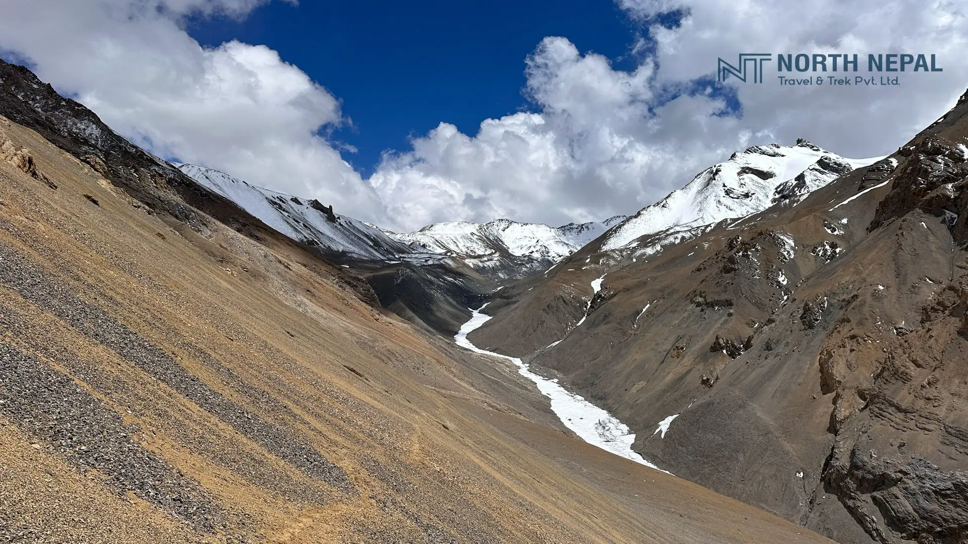
Rocky path and the clear rocky view on the way to Teri La base camp captured by North Nepal Trek during Teri La Pass Trek.
Photo: On the way to Teri La Base Camp

Walking further, we will encounter a steep ascending section that is quite challenging to climb and requires technical skills. Another reason, this portion is considered challenging is because it is a landslide area. After crossing this steep path, the rest of the trail is flat till we reach Teri La Base Camp.

This base camp is quite safe for camping as there is no risk of landslides, strong winds, or sudden changes in weather to the extreme. In addition, the views of the mountain peaks from here are breathtaking. Some of them are Teri Peak, Manang I, Manangu II, Manang III, and the north face of Chulu Peak.

Ascending further for a couple hundred meters, we also get a stunning view of Manaslu, Himlung, and many more. We then set up our camp and accommodated here for the night.

Day 12

Trek from Teri La Base Camp to Phapsu Khola via Teri La Pass

HIGHEST ALT. 5,577 m | 18,297 ft
DURATION 8 - 9 hrs
Distance
DISTANCE 22 km

Today, we pass through our core destination of the trip, Teri La Pass (5,577 meters), and then finally reach Phapsu Khola (4,745 meters). The day starts with a stunning view of the mountain peaks from the camp in the early morning.

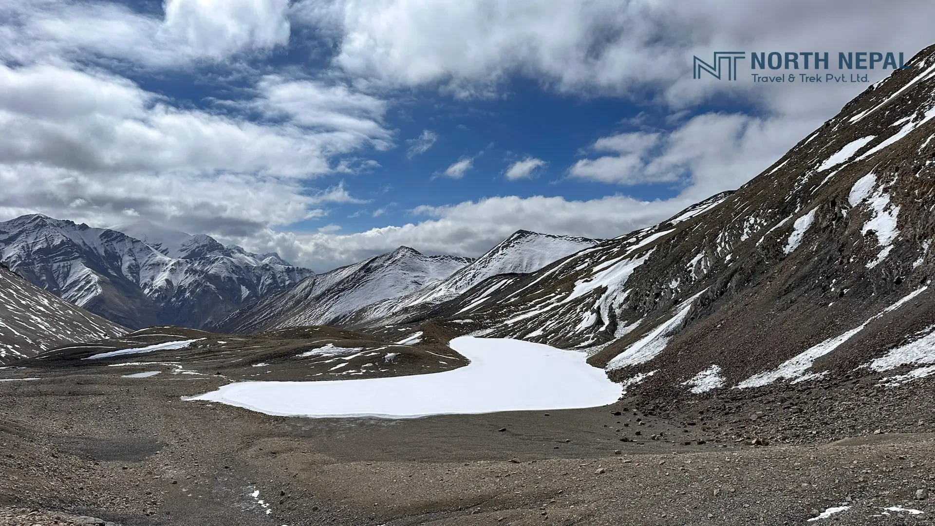
Completely frozen Moon Lake Captured by North Nepal Trek during Teri La Pass Trek.
Photo: Moon Lake

Since we will be passing through the Teri La Pass, so we won't have any place to prep our food in between. Hence, we will prepare our meals for the day and head towards Phapsu Khola.

As we trek towards the pass, we notice the trail is more desert-like in the high mountains as well. The trail today is also quite challenging as the path is mostly gravel with low oxygen levels at such an altitude.

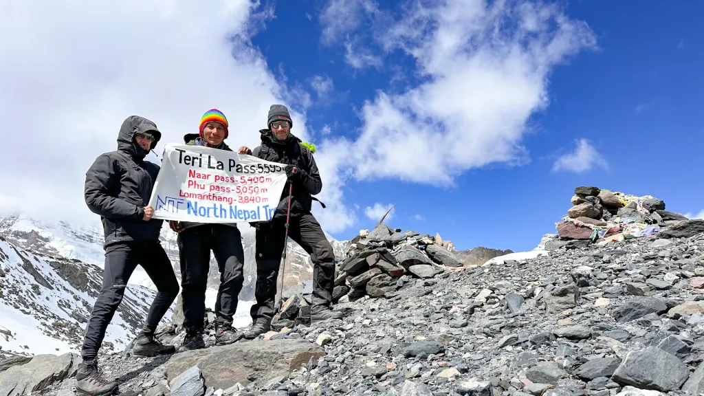
Guide Jeewan and two trekkers from North Nepal Trek posing with banner and excitement at top of Teri La Pass during Teri La Pass Trek
Photo: Teri La Pass

However, as we reach the top of the pass, we get a picturesque view of Manaslu, the north side of Dhaulagiri, and a few peaks of the Mustang Himalayan range. Walking further from the pass, on the deserted mountain, we will see a lake similar to the shape of the moon, also known as Moon Lake.We will be covering a total distance of 22 km today. Therefore, we will be ascending and descending multiple mountains to finally reach Phapsu Khola, where we will set our camp and accommodate for the night.

Day 13

Trek from Phapsu Khola to Yakpa 

HIGHEST ALT. 4,315 m | 14,156 ft
DURATION 5 - 6 hrs
Distance
DISTANCE 11 km

The trek from Papsu Khola (4,745 meters) to Yakpa (4,315 meters) offers a unique experience, particularly as you navigate the diverse landscape of Mustang. It is a stunning journey through rugged alpine terrain characterized by steep ups and downs. As you transition through this mountainous desert terrain, in the winter months you may encounter icy sections that add extra challenges but also enhance beauty.

Phapsu Khola Camp with rocky terrian captured by North Nepal Trek during Teri La Pass Trek.

In an arid environment, it is essential to carry enough water, as natural resources are sparse. We may find water at 4-5 hours of walking, so pack sufficient supplies to sustain during the trek. We then set our camp, have our prepared meals, and rest for the night.

Day 14

Trek from Yakpa to Tannge 

HIGHEST ALT. 3,338 m| 10,951 ft
DURATION 5 - 6 hrs
Distance
DISTANCE 8 km

On this day, we’ll traverse several high ridges before descending to the enchanting Mustang village of Tange (3,338 meters). The village comprises around 20 whitewashed houses built on terraced hills, and livestock, primarily sheep and goats to make a living.

The trek offers breathtaking views of some of the most iconic peaks including Dhaulagiri, Nilgiri, and Annapurna I. We pass near the Taange coal mine, which adds an interesting aspect to your trek but is also extra challenging due to the high temperature. We set our camp here and call it the end of the day.

Day 15

Trek from Tannge to Yara Village

HIGHEST ALT. 3,600 m| 11,811 ft
DURATION 6 -7 hrs
Distance
DISTANCE 13 km

The trek from Tannge(3,338 meters) to Yara(3,600 meters) features a well-maintained trail that allows for a more pleasant walking experience trail above Upper Mustang.

Tannge itself is a beautiful Tibetan village, characterized by its traditional architecture and stunning surroundings. As we move on further, we'll encounter ancient monasteries, Chorten, and the rock formation of Mustang.

While a trail could end at Yara to Jomsom, our customized itinerary continues to Lomanthang, Dhakmar, and Jomsom offering even more opportunities for exploration and adventure. So, for the night we accommodate here at Yara village and explore the rest of the Mustang in further days.

Day 16

Trek from Yara Village to Lo Manthang 

HIGHEST ALT. 3840 m | 12598 ft
DURATION 7 - 8 hrs
Distance
DISTANCE 17 km

Continuing the same trail from yesterday, with a beautiful landscape, today we will be reaching Lo Manthang (3,840 meters), the capital city of Mustang. Most of the communities here are of Buddhist religion so we will see chorthens, mani walls, monasteries, and gumba on the way.

The trail initially starts with a descent and finally, an ascend to reach Lo Manthang. Walking through the salt drips, narrow canyons, and soaring cliffs we encounter Sumdo or river junction. From here, we take a left turn, passing through a small canyon, we reach the walled city of Lo.

The people here are immersed in traditional Tibetan culture, we can see the reflection of their culture in their homes, lifestyle, food, and sacred places like monasteries and gumbas. For the night we will be accommodating in one of the tea shops or lodges.

Day 17

Rest Day at Lo Manthang

DURATION 7 - 8 hrs
Distance
DISTANCE 21 km

After days of trekking in the mountain desert, we need a rest day at Lo Manthang (3,840 m), also known as the Upper Mustang Region. Today, we will explore this capital city and experience its culture, food, and more.

This place holds great historical value for the Tibetan people and is also an important transit and trade point between Nepal and Tibet. We will visit multiple Gumbas built back in the 14th and 15th centuries along with some museums to understand their history.

Ascending a bit further from Lo Manthang, we will find other monasteries and gumbas as well which we can visit. Finally to conclude the day we enjoy the local food and rest for the night.

Day 18

Trek from Lo Manthang to Dhakmar

HIGHEST ALT. 3,840 m |13,780 ft
DURATION 6 - 7 hrs
Distance
DISTANCE 17 km

After a rest day at Lo Manthang (3,840 meters), we continue our trekking and head towards Dhakmar. The path is much better than any other day as it consists of trekking paths.

We start our day by leaving Lo Manthang and ascending to an altitude of 4,200 meters. From this point, we get a mesmerizing view of the mountain peaks. On the way, we will also visit Ghar Gompa, considered one of the older gompas of Nepal.

\Walking further we will see multiple yak farms both modern and traditional way. After walking for a couple of hours further we reach Dhakmar. The landscapes here are unique and fascinating from what we have seen in this entire journey. Known for deep gorges and towering cliffs, Dhakmar is also of great importance in its history and Tibetan culture.

One of the key things about Dhakmar is its red cliff, tourists even compare it with the great Grand Canyon. There is much more to explore in this historical village like Gumbas, monasteries, Thangkas paintings, etc. We will accommodate you here for the night.

Day 19

Drive from Dhakmar to Jomsom

HIGHEST ALT. 2,743 m | 8,999 ft

On this day, our walking journey finally comes to an end as we go from Dhakmar to Jomsom on a drive. After you have your breakfast in the hotel, our representatives will take you on a drive in a jeep. This will be one of the best drives you will ever enjoy in Nepal.

Passing through the rough and rugged route, watching the dry mountains, we reach Jomsom, the land of apple orchids. Store your backpacks in the hotel and stroll around Jomsom. Furthermore, we also encourage the trekkers to interact with the locals and try some locally prepared food items like apple chips and Marpha.

Day 20

Drive from Jomsom to Pokhara

HIGHEST ALT. 2,710 m | 8,891 ft
DURATION 155 km (Drive)

Today marks the last day of the Teri La Pass Trekking journey. Wake up early in the morning, have your breakfast, and our guides will pick you up from the hotel and take you on a scenic drive to Pokhara.

Share your experiences with fellow trekkers, have fun, and within the next few hours, we will reach Pokhara. From here, the trekkers can take on the bus to Kathmandu if we have enough time.

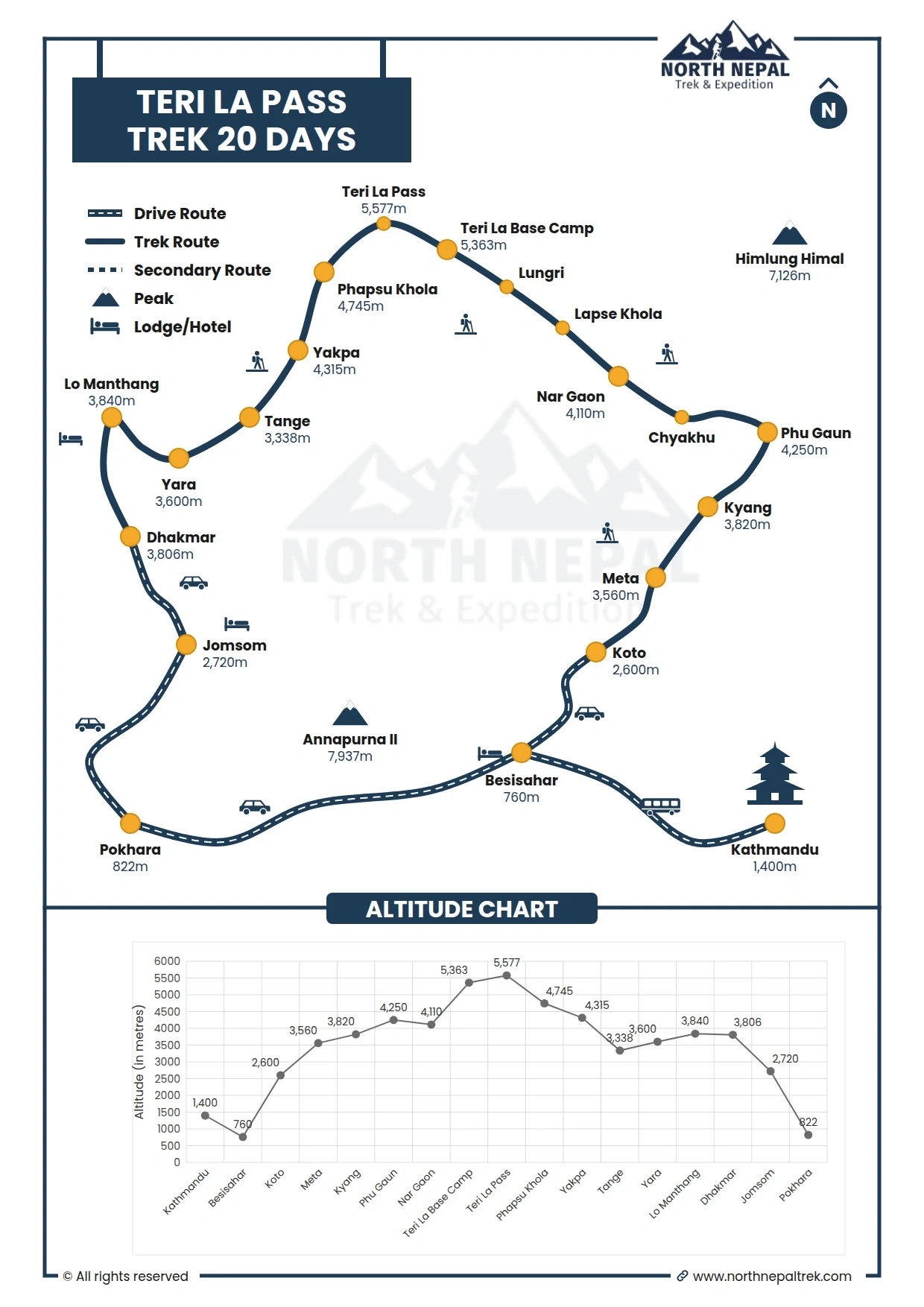
Teri La Pass Trek Map and Altitude Graph

Teri La Pass Trek Map and Altitude Graph

What's Included & Excluded

  • All meals: breakfast, lunch, and dinner throughout the trek from Kathmandu to Pokhara.
  • Tea, coffee, cookies, and hot water during the trek.
  • Tents for guests, Nepalese staff, kitchen, dining, and toilet. 
  • Guides, cooks, and required porters for the camping trip. 
  • All staff expenses, including meals, accommodation, salaries, equipment, insurance, and transportation.
  • Transportation arrangements for guests and crew throughout the trek.
  • All necessary trekking permits for Upper Mustang, Nar Phu, ACAP, and TIMS.
  • A kit bag for storing personal belongings and a duffel bag for porters.
  • Essential paperwork, including government and local taxes.
  • A certificate of appreciation from North Nepal Trekking after a successful trek.
  • Medical kit (carried by your trek leader).
  • Accommodations and transportation in Kathmandu and Pokhara
  •  Accommodations and meals in Kathmandu before and after our journey
  • Travel insurance, international airfare to and from Nepal
  • Alcoholic drinks, cold drinks, snacks, laundry, phone calls, and the internet
  • Personal trekking equipment and emergency evacuation equipment in case of an emergency
  • Any costs that arise due to a change of itinerary, because of landslides, bad weather, or any unforeseen circumstances 
  • The rent of horses and extra porters during the trek.
  • Tips for trekkers, porters, and drivers.
  • Any other expenses not mentioned in the inclusion section.

Complete Guide to the Teri La Pass Trek

Toggle all

Overview the Teri La Pass Trek

Connecting Upper Mustang and Nar Valley lies one of Nepal's most adventurous and unexplored treks, the Teri La Pass Trek. Unlike any other trekking route, where we often see dry mountains as the trail passes through the salt route that connects Manang to Upper Mustang. We find a different landscape here. Far from the crowded trekking route, desert-like terrain with alpine meadows, and a peaceful environment, it is full of adventure. 

Moreover, being a long camping trek in the Annapurna region, this trekking package offers a different level of adrenaline rush to the trekkers. Furthermore, the Teri La Pass Trek experiences less number of trekkers because of its remoteness. Moreover, let us also tell you that trekkers need to obtain permits to enter the restricted areas of Upper Mustang and Nar Phu village. Other than that, the Teri La Pass Trek, being a camping trek, requires proper gear and equipment. Furthermore, you shall also be aware of the fact that no human settlements exist from Naar Village up until we reach Upper Mustang. 

The thrilling trek starts through the fortified Tibetan villages in Nar Phu Valley. Situated on the northern side of the Annapurna circuit, the trek takes you through diverse terrain, from dry mountains and rocky paths to vibrant red cliffs and serene grassland. You’ll witness unique geological features, including areas with potential for copper and iron mining along the way.

The trek offers an opportunity to experience the unique lifestyle of local Bhottias (Nepali Tibetians) in Nar and Phu. We’ll discover the preserved culture of Nar Phu Valley, where traditional lifestyles remain untouched by modern influences. The stunning views of the Annapurna range, Manaslu range, Gangapurna, Tilicho Peak, and Himlung Himal further enhance the beauty of Nar Phu Valley.

As the journey progresses from Nar village, the terrain shifts to narrow paths alongside the Lapse (Khola) River. The trek exhibits more challenges, including riskier routes prone to landslides and loose stones, requiring trekkers to be physically and mentally prepared. There is mobile network connectivity in limited places, making it essential to travel in groups. The risk of altitude sickness increases as we ascend to higher elevations.

Starting from Koto, the trek passes through Meta, Kyang, NarPhedi, Chankhyu, Dharamshala, Lapse Khola, Papshu Khola, and villages such as Yakpa, Tange, and Yara. The Teri La Pass Trek offers an opportunity to explore the last forbidden kingdom of Lo-Manthang along the Kali Gandaki, the deepest river gorge in the world, descending through a beautifully carved, colorful gorge, concluding the trek.

Why you will love the Teri La Pass Trek?

  • Chance to explore the remote side of Upper Mustang
  • Experience the well-preserved local culture & lifestyle of Tibetans
  • Opportunity to explore the Lo-Manthang along with the deepest gorge, Kali Gandaki
  • A different picturesque view of the snow-capped mountains in desert-like landscapes
  • The comparatively less crowded trekking route with a few small settlements and locals en route
  • One of the major reasons to love the Teri La Pass Trekking Adventure is due to the Teri La Pass itself. Reaching the Teri La Pass is itself a rewarding achievement for the trekkers.

Best Time For Teri La Pass Trek

The best time to complete this thrilling expedition is near the end of the Spring season and early in the Monsoon season. Especially in August, September, and October, it is more favorable to do this trek.

The weather is gentle, allowing us to navigate the route easily with a great view of the landscapes and the snow-capped mountains. In the morning and after sunset, the temperature gets a bit colder, and during the daytime, the temperature is mild. Moreover, there is less chance of sudden changes in weather conditions that affect our schedule.

The flower blossom, and especially, we find different types of wildflowers on the path, making the route more scenic. Moreover, the picturesque view of the Mustang and Nar Phu Valley is much better in these seasons, making the journey worthwhile.

While there are chances of doing this journey in other seasons. However, it is not recommended, as the weather condition changes frequently and can get worse within a few moments.

Teri La Pass Trek Route

The Teri La Pass Trek offers an adventurous route connecting the remote Nar Phu Valley with the Upper Mustang. This trek takes you through a fascinating mix of cultural and natural landscapes, including ancient Tibetan-influenced villages, arid desert-like valleys, and dramatic Himalayan backdrops. Trekkers pass through high-altitude terrain, crossing the challenging Teri La Pass at 5,577 meters. Along the way, you'll encounter vibrant traditions, monasteries, and breathtaking views of snow-capped peaks, making it a perfect blend of cultural immersion and physical challenge in Nepal's hidden corners.

Teri La Pass Trek Key Points

  • Starts with a drive from Kathmandu to Koto
  • Travels through the secluded Nar Phu Valley with traditional villages
  • Nar village offers insight into Tibetan-influenced culture
  • Challenging ascent over Teri La Pass (5,577 meters)
  • Enters the Upper Mustang region with its distinct landscapes
  • Desert-like valleys and panoramic views of the Himalayas
  • Concludes in Jomsom, followed by a flight or drive to Pokhara

Teri La Pass Trek Total Trekking Distance

The Teri La Pass trek covers an extensive distance through rugged and remote terrain, demanding physical endurance over a variety of landscapes. The trek includes high-altitude ascents and descents, with certain days dedicated to acclimatization and shorter hikes, while others focus on covering more challenging distances. The combination of changing altitudes and remote paths adds to the adventure, making trekking a test of stamina and preparation.

Key points for Teri La Pass Trek

  • Total distance: Around 180 km (111 miles)
  • Duration: 19-20 days
  • Average daily distance: 10-12 km
  • Longest day: ~22 km (crossing the Teri La Pass)

The trek takes you through rugged landscapes, crossing high-altitude passes and remote valleys, requiring stamina and preparation for varying distances and challenges each day.

Teri La Pass Trek Distance and Duration Table

Days
Itinerary
Distance
Duration
Day 1
KTM|PKR to Koto (Drive)
175 km
9 -10 hrs
Day 2
Koto to Meta
14 km
7 hrs
Day 3
Meta to Kyang
6 km
4 - 5 hrs
Day 4
Kyang to Phu
8 km
5 - 6 hrs
Day 5
Acclimatization in Phu
(Phu to Himlung Base Camp)
9 km
5 - 6 hrs
Day 6
Phu to Chyakhu
8 km
4 hrs
Day 7
Chyakhu to Nar Gaon
10 km
5 - 6 hrs
Day 8
Rest Day at Nar Gaon
(rest)
(rest)
Day 9
Nar to Lapse Khola
17 km
6 - 7 hrs
Day 10
Lapse Khola to Lungri
15 km
6 -7 hrs
Day 11
Lungri to Teri La Base Camp
10 km 
5 - 6 hrs
Day 12
Teri La Base Camp to Phapsu Khola 
via Teri La Pass
22 km 
8 - 9 hrs
Day 13
Phapsu Khola to Yakpa
11 km 
5 - 6 hrs
Day 14
Yakpa to Tannge
8 km 
5 - 6 hrs
Day 15
Tannge to Yara
13 km 
6 - 7 hrs
Day 16
Yara to Lo Manthang
17 km 
7 - 8 hrs
Day 17
Lo Manthang (Exploration and Rest day)
21 km 
6 - 7 hrs
Day 18
Lo Manthang to Dhakmar
17 km
6 - 7 hrs
Day 19
Dhakmar to Jomsom (Drive)
---------
4 -5 hrs
Day 20
Jomsom to Pokhara (Drive)
155 km
7 - 8 hrs

Teri La Pass Trek Driving Distance and Total Duration

The trek begins and ends with long drives, setting up, and concluding the trekking journey. The main portion of the itinerary is spent trekking, with time for acclimatization and cultural exploration.

Key points

  • Kathmandu | Pokhara to Koto: ~250 km (9 -10 hours)
  • Jomsom to Pokhara: ~155 km (6-7 hours by road or 20-minute flight)
  • Total program duration: 19-20 days
  • 16-18 full trekking days

Challenges and Difficulties In the Teri La Pass Trek

While a fit individual can easily complete most treks in Nepal, the Teri La Pass Trek is an exception. The route perfectly suits people looking for a thrilling and adventurous journey. In addition, being able to sustain in high altitudes, having great physical fitness, and having further technical skills are required for passing through multiple rugged terrains.

Most of the trails are desert-like landscapes, which consist of rocky paths. This makes the trail more dangerous as the strong wind blows the rocks from high in the mountains and blocks our way. Moreover, trekking on these terrains is also quite challenging.

During our journey, we will spend 5 to 7 days trekking through the mountains. As we pass through Nar Village, the path gets a bit challenging as the trail gets narrower. The stones here are loosely coupled, making a constant threat of falling rocks. Also, there are some landslide areas in between. Therefore, we have to be cautious while passing through these areas.

Reaching a staggering altitude of 5,577m is challenging in itself. There is always a constant threat of altitude sickness in these ascents. Meanwhile, there are some sections in between, where we won't even have a cellular network for a few days. So, preparing for these situations and acclimatizing properly at different altitudes is crucial to adapting to the environment at higher points.

Packing & Gear for the Teri La Pass Trek

The Teri La Pass Trek crosses one of Nepal's most remote high-altitude routes, reaching Teri La Pass (5,577 m / 18,297 ft). Temperatures can fall well below freezing, with strong winds and snow possible even in spring and autumn. A proper layering system and high-quality trekking gear are essential for safety and comfort.

For a complete equipment checklist, visit our Trekking Gear List in Nepal:

Essential Gear

  • Waterproof trekking boots, thermal base layers, fleece, expedition down jacket, waterproof shell, insulated gloves, warm hat, UV sunglasses, 35–45L daypack, headlamp, and personal first-aid kit.

Seasonal Packing

  • Spring (Mar–May): Warm layers, gaiters, and trekking poles for snowfields.
  • Summer/Monsoon (Jun–Aug): Waterproof clothing, backpack cover, and quick-dry layers.
  • Autumn (Sep–Nov): Insulated jacket, thermal clothing, gloves, and windproof shell.
  • Winter (Dec–Feb): Expedition-weight down jacket, heavy thermal layers, insulated boots, microspikes or crampons if required, and extreme cold-weather accessories.

Free Gear from North Nepal Travel & Trek

When you book with North Nepal Travel & Trek, we provide free of charge:

  • Sleeping bag
  • Trekking poles
  • Duffel bag

Pack light but never compromise on cold-weather clothing. At 5,577 meters, reliable gear is essential for a safe and successful crossing of Teri La Pass.

Permits Required For the Teri La Pass Trek

Permits are crucial documents required while trekking in different parts of Nepal. It is a piece of documentation that allows us to pass through different sections in our journey.

Upper Mustang, which shares a border with Tibet, is home to the Teri La Pass. So it is a restricted area; therefore, trekking on this route requires Restricted Area Permit which is just USD 50 per day based on the revised RAP Fee by Government of Nepal. Below is the list of permits required during the Teri La Pass Trek:

  • Annapurna Conservation Area Permit: NPR 3,000 ($ 25 to 30) for Non-SAARC, NPR 1,000 for SAARC
  • Nar Phu Restriction Area Trekking Permit: $100 (Sep–Nov) / $75 (Dec–Aug) applies for all
  • Upper Mustang Restricted Area Permit: $50 per day for all (new permit)

Permits mentioned are all we require to do this trek without any interruption. Solo traveling is restricted in these areas, so we won't get any permits if we are traveling solo. Since it consists of passing through a restricted area, the number of permits given out each year is also quite low. Moreover, one thing that the trekkers must be aware of is that the cost of the permits for the Teri La Pass Trekking Adventure varies based on the season you choose.

Accommodation In Teri La Pass Trek

En route, we will find multiple tea shops and lodges for accommodation. These places will provide us with basic amenities and are feasible for staying overnight. In the early days, we could find multiple options from basic to standard ones accordingly.

Until Nar Village, we can find multiple teahouses and lodges. But as we move further in our journey, the accommodation is quite basic, with a shared bathroom. Not to mention, there will be days when we need to be accommodated in a camp.

Another important thing to remember is the backups we will require in our journey. As there won't be any cellular networks or power in between. Therefore, we will have to prepare beforehand for these situations.

Why choose North Nepal Trek for your Teri La Pass trek

  1. Guide Expertise: Local, certified, trained guides with in-depth knowledge of the terrain, culture, and hidden gems of the Annapurna region.
  2. Local Agency: Run by locals who live in the Himalayas, providing authentic insights and supporting the local economy.
  3. Flexibility: Customizable itineraries catering to any age group, ensuring a trek that matches your pace and preferences.
  4. Cultural Immersion: Unique opportunities to engage with local communities, thanks to the agency's strong regional connections.
  5. Safety First: Guides are well-versed in high-altitude safety protocols and emergency procedures.
  6. Sustainable Tourism: Commitment to eco-friendly practices and supporting local communities along the trekking routes.

Why Trek With Us - Teri La Pass Trek

Teri La Pass TrekCrossing the remote, high-altitude Teri La Pass and the restricted valleys beyond demands a team that knows this challenging route. Here is why trekkers choose North Nepal Travel & Trek:

100% Locally Owned & Pokhara-Based

We are based in Pokhara, so your booking stays local and directly supports the mountain communities along the Teri La route.

Officially Licensed & TAAN-Registered

A fully government-registered agency and active TAAN member, authorized to arrange the restricted-area permits this route requires, with full legal compliance and the highest safety standards.

Over a Decade on This High Pass

We have safely operated the Teri La Pass trek for more than ten years, mastering its 5,577 m crossing, weather windows, and acclimatization logistics.

Expert Local Leadership

Your expedition is personally led by our expert guide, a government-certified, English-speaking local leader who knows every step of the Teri La trail.

Top-Rated Client Satisfaction

Backed by a 4.9/5 review rating across global platforms for safety, local hospitality, and personalized service.

Travel Insurance Policy For Teri La Pass Trek

It is always recommended to have travel insurance while trekking in any part of Nepal. Talking about the Teri La Pass Trek is further situated in a remote area than other trekking routes. Also, we pass through some of the restricted areas with the help of necessary permits.

No matter how thrilling the journey is, there is always a constant risk of changing weather drastically, leading to some problems. And altitude sickness is common while ascending to such an altitude.

Therefore, getting travel insurance that covers emergency evacuation and medical assistance can be crucial in this journey.

Live Trail Update of Teri La Pass Trek - 20 Days Live

Last updated: 1 Week Ago

Updated: Uttam Pun

Trail Condition Generally in good condition
Weather Generally favorable trekking weather
Wifi/Network Unreliable above 2,000 m
Teahouses Open and often crowded

Trekker Alerts

  • Water filters recommended
  • ATM unavailable
Reviews From The Trail

Hear it from those who've walked with us.


Safety Policy

Professional & Certified Guides

Every trek is accompanied by an experienced, licensed, English-speaking local guide trained in high-altitude wilderness survival, remote navigation, and first-aid response. Guides carry comprehensive medical kits equipped with essential high-altitude pharmaceuticals and pulse oximeters to monitor oxygen saturation levels daily during the ascent through Nar-Phu and Upper Mustang.

High-Altitude Acclimatization & AMS Management

Itineraries are structured with careful elevation profiles and gradual altitude gains to ensure proper acclimatization before reaching extreme high-altitude points like Teri La Pass (5,577 m). Guides conduct rigorous daily health assessments for early symptoms of Acute Mountain Sickness (AMS). If severe symptoms appear, standard protocol mandates immediate descent to lower elevations.

Emergency Rescue Coordination

In cases of severe injury, acute altitude illness, or extreme weather conditions on remote, high-altitude camping trails, emergency helicopter evacuation is coordinated directly through local rescue services. Evacuations are initiated promptly upon assessment by your guide in communication with our Pokhara and Kathmandu offices.

Mandatory Travel Insurance

All trekkers must hold comprehensive travel insurance covering emergency medical treatment, high-altitude trekking and camping (up to 6,000 m), and emergency helicopter rescue/evacuation. Insurance details must be submitted prior to the departure of the trek to streamline emergency logistics if required.


Teri La Pass Trek Departure Date for 2026/2027

Secure the Teri La Pass Trek for 2026/2027 before the seat gets fully booked.


Terms, Conditions & Feasibility

  1. All bookings are made with North Nepal Travel & Trek Pvt. Ltd Registered Company Number 162883/073/074 (hereafter referred to as The Company) whose office is in Lakeside, Pokhara-6, Nepal.
  2. The term "trip" used in this website and booking conditions refers to all itineraries described on this website including those which might otherwise be known as walking, tours, trekking trips, sightseeing, climbing, mountaineering, expeditions, or holidays.
  3. We accept your last-minute booking as well, but full payment of the total tour cost should be made in advance if necessary or can be paid fully on arrival day. See More


Frequently Asked Questions

General Information

1. What is the Teri La Pass Trek and where is it?

The Teri La Pass Trek is a challenging 20-day expedition connecting the remote Nar Phu Valley in Manang with Upper Mustang. The route follows an old trans-Himalayan trade corridor through some of Nepal's least-developed high-altitude terrain before crossing Teri La Pass and continuing toward Mustang.

The trek combines restricted-area valleys, high-altitude camping, dramatic mountain landscapes and the stark Trans-Himalayan terrain of northern Nepal.

2. How high is Teri La Pass?

Teri La Pass reaches approximately 5,577m (18,297 ft), making it the highest point of this itinerary and one of the most demanding pass crossings in the region.

The pass crossing is scheduled for Day 12 and is approximately 22 km with 8 to 9 hours of trekking, depending on conditions and the exact route followed.

3. How difficult is the Teri La Pass Trek?

The trek is graded Challenging and is intended for experienced trekkers.

The difficulty comes from the combination of a 5,577m pass, long trekking days, remote terrain, restricted-area logistics and several nights of camping in potentially sub-zero conditions. Previous experience at high altitude is strongly recommended.

4. Is Teri La suitable for beginners?

No. This is not an appropriate first Himalayan trek. The route requires sustained physical effort over 20 days and includes a very high pass crossing in remote terrain.

Trekkers should be comfortable with long mountain days, high-altitude conditions and camping away from permanent settlements.

5. What makes the Teri La Trek different from the Annapurna Circuit?

The Annapurna Circuit is a well-established teahouse route with extensive infrastructure and the famous Thorong La Pass.

The Teri La Trek is considerably more remote. It connects Nar Phu and Upper Mustang, crosses Teri La at approximately 5,577m and requires extended camping in areas with little or no permanent infrastructure.

It is therefore better suited to experienced trekkers looking for a wilderness expedition rather than a conventional teahouse trek.

6. Can I combine Teri La with Upper Mustang or Nar Phu?

Yes. Teri La can be incorporated into a longer itinerary connecting Nar Phu and Upper Mustang, while Nar Phu and Upper Mustang can also be arranged as standalone trekking experiences.

The final itinerary can be planned around your available time, trekking experience and interests.

Cultural Insights

1. What is the cultural significance of the Teri La route?

The route follows an ancient trans-Himalayan corridor associated with trade and movement between the Nar Phu Valley, Manang and Mustang, linking communities on the southern side of the Himalayas with the Tibetan plateau.

The journey provides an opportunity to experience the distinctive Tibetan-influenced culture, architecture and traditions of the remote northern Himalayan communities.

2. What cultural regions does the trek connect?

The trek connects two culturally distinctive restricted areas:

  • Nar Phu Valley in Manang
  • Upper Mustang

Both retain strong Tibetan cultural influences, while their villages, monasteries, landscapes and local traditions have developed distinct identities.

Trekking Permits & Logistics

1. Which restricted areas does the Teri La Trek enter?

The route enters two restricted trekking areas:

  • Nar Phu Valley Restricted Area
  • Upper Mustang Restricted Area

This makes permit planning an important part of the expedition.

2. What permits are required for the Teri La Pass Trek?

The supplied itinerary requires three principal permits:

  1. Annapurna Conservation Area Permit (ACAP)
  2. Nar Phu Valley Restricted Area Permit
  3. Upper Mustang Restricted Area Permit

The Upper Mustang permit uses the revised rate applicable from November 2025, according to the package information.

3. Can I arrange the restricted-area permits independently?

The restricted-area permits require the appropriate documentation and organized trekking arrangements. For a combined Nar Phu and Upper Mustang expedition, it is much more practical to have an experienced trekking agency handle the permit process and logistics.

4. Is TIMS included in the Teri La FAQ?

No. TIMS is not listed as an included permit in this FAQ.

Health & Safety

1. Is altitude sickness a concern on the Teri La Pass Trek?

Yes. Altitude is one of the major safety considerations. The trek reaches 5,577m, and the pass crossing involves a substantial increase in elevation and a long trekking day.

Good acclimatization, sensible pacing, hydration and close monitoring for altitude-related symptoms are essential.

2. What happens if the weather prevents the Teri La crossing?

The pass crossing depends on actual mountain conditions. Snowfall, strong winds, poor visibility or unstable conditions can make a crossing unsafe.

The itinerary should remain flexible enough for the guide to delay, modify or cancel the crossing if conditions present an unacceptable risk.

3. Do I need previous high-altitude trekking experience?

Yes. Experience above 4,000m is strongly recommended, particularly because the route combines high altitude with remote camping and limited infrastructure.

4. Is travel insurance necessary?

Comprehensive travel insurance is strongly recommended. Your policy should specifically cover high-altitude trekking at the maximum elevation of the itinerary and emergency medical evacuation, including helicopter evacuation where available and medically appropriate.

Accommodation & Food

1. Is camping required on the Teri La Pass Trek?

Yes. A substantial section of the route requires camping because permanent lodges and teahouses are not available.

From the remote section around Nar Village, through the Teri La crossing and into the early Upper Mustang section, accommodation is provided through the expedition's camping setup.

2. Who provides the food during the camping section?

The trekking support team carries the required food and camping supplies. A cook and kitchen crew prepare meals throughout the camping section.

3. Are there teahouses on the entire route?

No. Some sections have lodge or guesthouse accommodation, particularly around established villages, but the high and remote sections between Nar Phu and Upper Mustang require organized camping.

Weather & Seasons

1. What is the best time for the Teri La Pass Trek?

The preferred trekking window is late August through October, with September generally considered the strongest month for the pass crossing.

Weather at 5,577m can change rapidly, so even during the recommended season the actual crossing depends on current conditions.

2. Can I cross Teri La outside the recommended season?

It is not advisable to treat the pass as a year-round crossing. Snow, strong winds and poor visibility can significantly increase the difficulty and risk.

The final decision should always be based on actual trail and weather conditions.

Packing Gear & Rental

1. What should I pack for the Teri La Pass Trek?

This is a high-altitude camping expedition, so your equipment needs to be appropriate for cold and changing mountain conditions.

Essential personal equipment includes:

  • High-quality trekking boots
  • Warm sleeping bag suitable for sub-zero conditions
  • Down or insulated jacket
  • Thermal base layers
  • Fleece or warm mid-layers
  • Waterproof jacket and trousers
  • Warm gloves
  • Warm hat or balaclava
  • Sunglasses
  • Sunscreen
  • Headlamp and spare batteries
  • Trekking poles
  • Water bottles or hydration system
  • Personal medication
  • Basic first-aid supplies
  • Duffel bag and daypack

2. Do I need special equipment for the Teri La crossing?

The exact equipment depends on seasonal snow and current conditions. Trekkers should be prepared for snow, freezing temperatures, strong wind and exposed high-altitude terrain.

Your trekking agency should provide a final equipment recommendation before departure based on the expected conditions.

Payments & Extra Costs

1. How much does the Teri La Pass Trek cost?

The supplied package price ranges from approximately USD 3,000 to USD 3,680 per person, depending on group size.

The higher cost reflects the 20-day duration, restricted-area permits, camping logistics, support crew, food supplies and specialist guide support required for the route.

2. What makes this trek more expensive than a normal teahouse trek?

The cost is influenced by:

  • Two restricted-area permits
  • Extended camping
  • Cook and kitchen crew
  • Porters and support staff
  • Camping equipment
  • Remote food and logistics supply
  • High-altitude guide expertise
  • Satellite communication
  • Long transportation arrangements

3. What personal expenses should I budget for?

Personal expenses such as drinks, snacks, charging, tips, personal equipment, travel insurance and other purchases should be budgeted separately unless specifically included in your final package.

Booking & Company Policies

1. Can I do the Teri La Pass Trek solo?

No. Because the itinerary enters Nar Phu and Upper Mustang restricted areas, the trek must be organized according to the permit and guide requirements applicable to those restricted zones.

A private trek for one traveller can be arranged only if the required restricted-area arrangements and minimum group requirements are satisfied.

2. How far in advance should I book?

Early booking is recommended because the trek requires multiple restricted-area permits, specialist guides, camping staff, transportation and extensive logistical preparation.

3. Can the 20-day itinerary be customized?

Yes. The Teri La route can be combined with or extended into other Himalayan itineraries, subject to permit rules, available trekking days, seasonal access and the physical demands of the route.

4. Why choose North Nepal Travel & Trek for Teri La?

The Teri La route requires significantly more logistical planning than a standard teahouse trek. North Nepal Travel & Trek can coordinate restricted-area permits, guides, porters, camping equipment, kitchen crew, meals, transportation and remote-route logistics as one organized expedition.

Transportation

1. How do I reach the Teri La Trek starting point?

The exact road approach depends on the selected 20-day itinerary. Transportation is used to connect the main trailheads and established settlements before and after the remote trekking sections.

2. Is transportation included?

Transportation is included according to the package itinerary. Exact vehicle arrangements and road sectors should be confirmed in the final trip plan because mountain road conditions can change.

Wifi/Network and Communication

1. Is mobile network available on the Teri La Trek?

Connectivity is limited and unreliable in the remote sections of Nar Phu and Upper Mustang. Trekkers should be prepared to spend several days without normal mobile coverage.

2. Is WiFi available?

Reliable WiFi should not be expected during the remote camping sections. Some established villages may have limited connectivity, but the high-altitude crossing has no normal internet infrastructure.

3. How is emergency communication handled?

The supplied package includes satellite communication, which is particularly valuable on a route where mobile connectivity can disappear for extended periods.

Wildlife & Nature

1. What landscapes can I see on the Teri La Pass Trek?

The trek crosses an extraordinary range of Himalayan environments, from the deep valleys of Nar Phu to high alpine terrain and the dry Trans-Himalayan landscape of Upper Mustang.

The scenery changes dramatically as you cross from the wetter southern side of the mountains toward the arid Mustang plateau.

2. What can I see from Teri La Pass?

From around 5,577m, the route provides expansive views across the high Himalayan landscape and toward the dramatic terrain of Upper Mustang.

The descent reveals the stark, dry landscapes associated with the Kali Gandaki valley and the Trans-Himalayan plateau.

3. What makes the Upper Mustang landscape different?

Upper Mustang lies in a Himalayan rain-shadow environment, producing a markedly dry landscape characterized by eroded cliffs, barren hills, deep valleys and desert-like terrain.

The contrast between this environment and the greener landscapes of lower Manang is one of the defining features of the Teri La expedition.

PRIVATE TRIP

20 Days

Price Start from USD 4000

USD 3680 pp

We Offer Group Discount

No. of PersonsPrice per Person
2 person US$ 3680
3-6 person US$ 3400
7-12 Person US$ 3200
13-20 Person US$ 3000
RECOGNISED · CERTIFIED · TRUSTED

We are associated with